Ezmap, A Map-Drawing Package
David J. Kennison
NCAR, P.O. Box 3000, Boulder, Colorado 80307-3000
email: kennison@ucar.edu (128.117.14.4)
Table of Contents
INTRODUCTION
PROJECTIONS
ROUTINES
MAPACI (IAID)
MAPBLA (IAMA)
MAPBLM (IAMA,XCRA,YCRA,MCRA, . . . )
MAPDRW
MAPEOD (NOUT,NSEG,IDLS,IDRS,NPTS,PNTS)
MAPFST (RLAT,RLON)
MAPGCI (ALAT,ALON,BLAT,BLON,NOPI,RLTI,RLNI)
MAPGRD
MAPGRM (IAMA,XCRA,YCRA,MCRA, . . . )
MAPGTx (PNAM,xVAL) or MPGETx (PNAM,xVAL)
MAPINT
MAPIQ
MAPIQA (IAMA,IGID,IAIL,IAIR)
MAPIQD
MAPIQM (IAMA,XCRA,YCRA,MCRA, . . . )
MAPIT (RLAT,RLON,IFST)
MAPITA (RLAT,RLON,IFST,IAMA,IGID,IAIL,IAIR)
MAPITD (RLAT,RLON,IFST)
MAPITM (RLAT,RLON,IFST,IAMA,XCRA,YCRA,MCRA, . . . )
MAPLBL
MAPLOT
MAPPOS (XLOW,XROW,YBOW,YTOW)
MAPROJ (JPRJ,PLAT,PLON,ROTA)
MAPRS
MAPRST (IFNO)
MAPSAV (IFNO)
MAPSET (JLTS,PLM1,PLM2,PLM3,PLM4)
MAPSTx (PNAM,xVAL) or MPSETx (PNAM,xVAL)
MAPTRA (RLAT,RLON,UVAL,VVAL)
MAPTRI (UVAL,VVAL,RLAT,RLON)
MAPTRN (RLAT,RLON,UVAL,VVAL)
MAPUSR (IPRT)
MAPVEC (RLAT,RLON)
MPCHLN (IACT,ILTY,IOAL,IOAR,NPTS,PNTS)
MPFNME (IAIN,ILVL)
MPGETx (PNAM,xVAL) and MPSETx (PNAM,xVAL)
MPGLTY (ILTY)
MPIATY (IAIN)
MPIFNB (CHRS)
MPILNB (CHRS)
MPIOLA (IAIN,ILVL)
MPIOSA (IAIN,ILVL)
MPIPAI (IAIN,IAIP)
MPIPAN (IAIN,ANME)
MPIPAR (IAIN)
MPISCI (IAIN)
MPLNAM (FLNM,ILVL,IAMA)
MPLNDM (FLNM,ILVL,IAMA,XCRA,YCRA,MCRA, . . . )
MPLNDR (FLNM,ILVL)
MPLNRI (FLNM)
MPNAME (IAIN)
MPRSET
SUPCON (RLAT,RLON,UVAL,VVAL)
SUPMAP (JPRJ,PLAT,PLON,ROTA, . . . )
INTERNAL PARAMETERS
ERROR HANDLING
EXAMPLES
AREA IDENTIFIERS
MISCELLANY
This document describes an NCAR Graphics package named EZMAP, which allows
one to plot maps of the earth according to any of ten different projections,
with parallels, meridians, and continental, international, and/or U.S. state
outlines. The origin and orientation of the projection may be selected by
the user. Points on the earth defined by latitude and longitude are mapped
to points in a projection plane, referred to as the u/v plane. A rectangular
perimeter whose sides are parallel to the u and v axes is chosen; material
within that perimeter (or an inscribed elliptical perimeter) is mapped to
the plane of the plotter (referred to as the x/y plane) for plotting. The
u and v axes are parallel to the x and y axes, respectively.
Also described in this document are routines from a package originally
named EZMAPA (added about 1986 or 1987), which, among other things, allows
the user to produce solid-filled maps of the earth, and a package originally
named EZMAPB (added in 1998), which provides access to improved map databases
(principally one called "Earth..1", which contains a unified higher-resolution
version of everything that was in the old outline datasets).
Principal sections of this document are as follows:
- The rest of this "INTRODUCTION" gives an overview of EZMAP,
with short descriptions of all the available subroutines.
- The section "PROJECTIONS" describes
the projections of the earth that may be used.
- The section "ROUTINES" gives detailed
descriptions of all available subroutines.
- The section "INTERNAL PARAMETERS"
describes all the internal parameters of the package; each internal
parameter affects some aspect of the behavior of one or more of the
routines in the package.
- The section "ERROR HANDLING"
describes all the conditions that are recognized as errors and what
can be done to recover from an error.
- The section "EXAMPLES" describes
examples that are available to illustrate the use of the package; some
users may wish to obtain the code for these examples and run them so as
to have them available for reference while reading further.
- The section "AREA IDENTIFIERS"
lists all the area identifiers that are used by EZMAP. User knowledge
of these is necessary for some purposes.
- The section named "MISCELLANY" gives
information that will be of interest to a few users.
To draw the simple map defined by the current values of EZMAP's internal
parameters (assuming no area fills and no access to the new, improved, map
database "Earth..1", which was created in 1998), one need only execute the
single FORTRAN statement "CALL MAPDRW":
- MAPDRW - Draws a complete simple map.
MAPDRW simply calls four lower-level routines. In many situations, the
user will wish to call these routines directly; they are as follows (in
the order in which they are called by MAPDRW):
- MAPINT - Initializes. MAPINT must be
called at least once before calling any routine that depends on mapping
lat/lon coordinates into u/v coordinates. After one or more of MAPPOS,
MAPROJ, and MAPSET has been called, MAPINT must be called again.
MAPINT does the call to the SPPS routine SET that defines the mapping
from the u/v (projection) plane to the x/y (plotter) plane.
- MAPGRD - Draws selected parallels and
meridians.
- MAPLBL - Labels the international date
line, the equator, the Greenwich meridian, and the poles, and draws the
perimeter.
- MAPLOT - Draws selected geographic
outlines. Note that this routine uses whichever old outline dataset
is selected by the value of the internal parameter 'OU'; to access
the new map database "Earth..1", which was created in 1998, one must
call instead the EZMAPB routine MPLNDR (which see, below).
The following routines are called to change the values of internal
parameters of EZMAP, and thus change the behavior of other EZMAP
routines:
- MAPPOS - Determines the portion of the
plotter frame to be used.
- MAPROJ - Determines the projection to be
used.
- MAPSET - Determines the portion of the
u/v plane to be viewed.
- MAPSTC
(or MPSETC) - Sets a parameter value of
type CHARACTER.
- MAPSTI
(or MPSETI) - Sets a parameter value of
type INTEGER.
- MAPSTL
(or MPSETL) - Sets a parameter value of
type LOGICAL.
- MAPSTR
(or MPSETR) - Sets a parameter value of
type REAL.
The following routines are used to retrieve the current values of EZMAP
parameters:
- MAPGTC
(or MPGETC) - Gets a parameter value of
type CHARACTER.
- MAPGTI
(or MPGETI) - Gets a parameter value of
type INTEGER.
- MAPGTL
(or MPGETL) - Gets a parameter value of
type LOGICAL.
- MAPGTR
(or MPGETR) - Gets a parameter value of
type REAL.
To save/restore the current values of the internal parameters of EZMAP,
use the following:
- MAPSAV - Saves the values (by writing a
record on a user-specified unit).
- MAPRST - Restores saved values (by reading
a record from a user-specified unit).
To draw objects on the map, use the following routines:
- MAPTRA - Computes the u/v coordinates of
a point from its latitude and longitude. If the point is unprojectable
or its projection lies outside the current perimeter, a special value
is returned to signal this.
- MAPTRN - Computes the u/v coordinates of
a point from its latitude and longitude. If the point is unprojectable,
a special value is returned to signal this, but no check is made for
a projected value being outside the perimeter.
- MAPFST - Does a "pen-up" move defining
the start of a line to be projected and drawn. The line is defined by
a series of lat/lon coordinates.
- MAPVEC - Does a "pen-down" move defining
the continuation of a line to be projected and drawn. The line is
defined by a series of lat/lon coordinates.
- MAPIT - Does "pen-up" or "pen-down"
moves. This routine is called by MAPFST and MAPVEC.
- MAPIQ - Signals the end of a string of
calls to MAPIT and causes its buffers to be flushed.
- MAPITD - Does "pen-up" or "pen-down"
moves. Like MAPIT, but the new dash package DASHPACK is called instead
of the old DASHCHAR.
- MAPIQD - Signals the end of a string of
calls to MAPITD and causes its buffers to be flushed.
- MAPGCI - Given the latitudes and
longitudes of two points on the surface of the globe, this routine
returns the latitudes and longitudes of a specified number of points
along the great circle route joining them.
The following routine was added to EZMAP early in 1992:
- MAPTRI - Computes the latitude and
longitude of a point from its u/v coordinates. If the point is outside
the boundary of the map, a special value is returned.
The example named "mpex10" shows one of the ways
in which this routine may be used; it draws what is essentially a colored
contour plot of a data field defined on the surface of the globe, using
an orthographic projection.
In late 1986 or early 1987, a package of routines was written allowing a
user to draw solid-filled maps of the globe. This package was named EZMAPA
and was first advertised in the NCAR Graphics User's Guide (Version 2.00),
published in August, 1987. Conceptually, the routines of EZMAPA are just
part of EZMAP; they use the same common blocks and many of the same
underlying low-level routines and they are affected by the same set of
internal parameters as the routines of EZMAP proper. The EZMAPA routines
will be described in this document; to use them effectively, it will be
necessary to understand also the package AREAS, which is described in a
separate document. The EZMAPA routines are as follows:
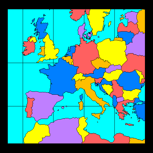
- MAPBLA - Adds boundary lines to an
existing area map. Routines in the package AREAS may then be used
to process that area map in various ways. (Example: drawing a map of
Europe with each country in a different color.) Note that this routine
uses whichever old outline dataset is selected by the value of the
internal parameter 'OU'; to access the new map database "Earth..1",
which was created in 1998, one must call instead the EZMAPB routine
MPLNAM (which see, below).
- MAPBLM - Draws boundary lines "masked" by
an existing area map. (Example: drawing these lines only where they
do not overlay CONPACK labels.) Note that this routine uses whichever
old outline dataset is selected by the value of the internal parameter
'OU'; to access the new map database "Earth..1", which was created
in 1998, one must call instead the EZMAPB routine MPLNDM (which see,
below).
- MAPGRM - Draws selected parallels and
meridians "masked" by an existing area map. (Example: drawing these
lines over water, but not over land.)
- MAPITA and
MAPIQA - Add to an area map the projections
of arbitrary lines defined by lat/lon coordinates of points on the
surface of the globe. MAPBLA and MPLNAM both use these routines to add
boundary lines to an area map; they may be called directly by the
user to add his/her own set of boundary lines to the area map.
- MAPITM and
MAPIQM - Draw, masked by an area map, the
projections of arbitrary lines defined by the lat/lon coordinates of
points on the surface of the globe. MAPBLM, MAPGRM, and MPLNDM all use
these routines to draw lines masked by the contents of an area map;
they may be called directly by the user to draw other masked lines.
- MAPACI - A function which, given the "area
identifier" for a particular area defined by the boundaries in one of
the old EZMAP outline datasets, returns a suggested color index for
that area; it is guaranteed that, if the suggested color indices are
used, no two areas having a boundary in common will have the same color.
Note that this function should not be used to select color
indices for areas defined by the new map database "Earth..1", which
was created in 1998; for that purpose, use EZMAPB functions instead
(in particular, MPISCI).
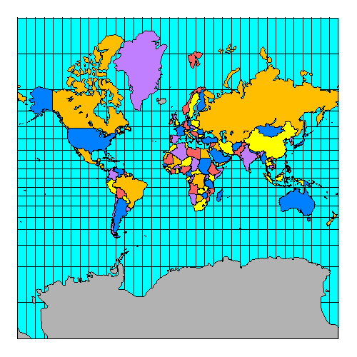
In early 1998, a new world map database, called "Earth..1", was created for
use with EZMAP; this database has higher-resolution coastlines, it has been
updated to reflect many of the political changes that have taken place over
the years since EZMAP came into existence, and it is structured differently,
allowing for greater flexibility and ease of use and providing for easier
changes and extensions in the future.
Each area defined by the database has 1) a "area identifier" (an integer
uniquely identifying it), 2) an "area type" specifying its level in a
hierarchy of areas, 3) a suggested color index, 4) an area identifier
specifying its "parent" area (the area of which it is a part), and 5) a
name. For example, there is an area named "Madeline Island" which is of
type 4 (used for a state or a portion thereof) and has suggested color
index 6. Its parent is an area named "Wisconsin", which is also of type
4 and has suggested color index 6. The parent of "Wisconsin" is
"Conterminous US", which is of type 3 (used for a country or a portion
thereof) and has suggested color index 3. The parent of "Conterminous
US" is "United States", which is also of type 3 and has suggested color
index 3. The parent of "United States" is "North America", which is of
type 2 and has suggested color index 5. The parent of "North America"
is "Land", which is of type 1 and has suggested color index 2. The area
named "Land" is at the top of the hierarchy and therefore has no parent
(when you ask for the area identifier of its parent, you get a zero).
One may use the database at any of five specified hierarchical levels:
1 => land/water, 2 => continents, 3 => countries, 4 => states, and 5 =>
counties (so far, no counties are included). When the database is used
at a particular level, entities that exist only at lower levels (larger
level numbers) effectively disappear.
The new database was created from data available on the World Wide Web,
using a new interactive editor based on NCAR Graphics. There are plans
to make this editor available, so that a knowledgeable user can create
a database tailored to his or her own needs: for example (assuming that
one can obtain the necessary outline data), it should now be relatively
easy to create and use a Pangaea database with EZMAP.
A new package of routines is used to access "Earth..1" and other databases
in the same format; this package is called EZMAPB. Conceptually, the
EZMAPB routines are just part of EZMAP; they use the same common blocks
and many of the same underlying low-level routines and they are affected
by the same set of internal parameters as the routines in EZMAP proper.
The principal EZMAPB routines are as follows:
- MPLNAM (MaP LiNes, to Area Map) - A
routine to extract boundary lines from a specified database and send
them to an area map.
- MPLNDM (MaP LiNes, Draw Masked) - A
routine to extract boundary lines from a specified database and draw
them, masked by the contents of an area map.
- MPLNDR (MaP LiNes, Draw) - A routine to
extract boundary lines from a specified database and draw them.
- MPLNRI - A routine to force the reading
of certain information from a database into labelled COMMON blocks
inside EZMAP, so that subsequent references to some of the functions
described below will have that information to work with. (Each of
the routines MPLNAM, MPLNDM, and MPLNDR reads this data as a side
effect; MPLNRI is provided for use in cases in which none of the
other three routines has yet been called.)
As each of the EZMAPB routines MPLNAM, MPLNDM, and MPLNDR processes
boundary lines from a specified database, it calls an EZMAPB routine
named MPCHLN (the default version of which does nothing):
- MPCHLN - A user-replaceable routine that
can be made to change line style, color, line width, and so on as the
boundary lines from a database are being drawn; it can also be made to
delete particular lines or to change the area identifiers associated
with them. The arguments of MPCHLN tell it which of the EZMAPB
routines is calling it and whether it's being called before or after
the line is processed; they also supply the "line type" of the line
being drawn, the area identifiers of the areas on either side of it,
and the actual coordinates defining the line. Line types are similar
to area types (1 => land/water, 2 => continents, 3 => countries, 4 =>
states, and 5 => counties).
Another EZMAPB routine, named MPGLTY, may be called by the user from within
the line-processing routine specified by the final argument in a call to
MPLNDM:
- MPGLTY - Retrieves the line type of
the line being drawn.
There is a group of EZMAPB functions providing access to information about
the areas defined by a database being used; these may be referenced at any
time the appropriate information has been loaded into EZMAPB's common
blocks (that is, after calling one of MPLNAM, MPLNDM, MPLNDR, or MPLNRI),
but they are normally to be referenced from within the area-processing
routine specified as the final argument in a call to the AREAS routine
ARSCAM, in which they may be used to obtain information determining the
manner in which the areas are to be rendered:
- MPIPAI - A function whose value is
non-zero if and only if the area with a specified area identifier
is part of the area having a second specified area identifier.
- MPIPAN - A function whose value is
non-zero if and only if the area with a specified area identifier
is part of the area having a specified name.
- MPIOLA - A function whose value is
the area identifier of the largest area that is defined at or above
a specified level in the area hierarchy and of which the area having
a specified area identifier is a part.
- MPIOSA - A function whose value is
the area identifier of the smallest area that is defined at or above
a specified level in the area hierarchy and of which the area having
a specified area identifier is a part.
- MPIATY - A function whose value is
the type of the area having a specified area identifier.
- MPIPAR - A function whose value is
the area identifier of the parent of the area having a specified
area identifier.
- MPISCI - A function whose value is
the suggested color index for an area having a specified area
identifier.
- MPNAME - A function whose value is
the name of the area having a particular area identifier.
- MPFNME - A function whose value is
the full name of the area having a specified area identifier, up
to a specified level in the hierarchy of areas; the full name of an
area consists of its own name, preceded by the name of its parent,
preceded by the name of its parent's parent, and so on; the various
components of the name are separated by the 3-character string ' - '
(a blank, a dash, and another blank).
Two additional EZMAPB functions are provided; these have nothing to do with
mapping, really, but can be useful in dealing with character strings:
- MPIFNB - A function whose value is
the index of the first non-blank character in a character string.
- MPILNB - A function whose value is
the index of the last non-blank character in a character string.
The following EZMAP routines are used for the purposes stated:
- MAPEOD - This routine is called by the
EZMAP routine MAPLOT and the EZMAPA routines MAPBLA and MAPBLM; in each
case, it is called once for each segment in the outline dataset. The
user may supply a version which examines the segment to see if it ought
to be used and, if not, to delete it. This can be used (for example)
to reduce the clutter in northern Canada. Note that this routine is
not called by any of the EZMAPB routines; for the same purpose, they
call the routine MPCHLN.
- MAPRS - Re-executes the "CALL SET" done
during the last call to MAPINT. This is useful when there has been
an intervening call to a utility that calls SET. It is quite common
for a background drawn by EZMAP to be placed in a flash buffer (as
created by the package "GFLASH"). When the contents of the flash
buffer are copied to the metafile being created, if it is desired to
draw something on the EZMAP background, MAPRS may first have to be
called to ensure that the correct SET call is in effect.
- MAPUSR - This routine is called by various
EZMAP routines just before and just after drawing parts of the map. By
default, grid lines are drawn using software dashed lines and
geographical outlines are drawn using either solid lines or dotted
lines. The dash pattern used for the grid lines, the flag which says
whether outlines are solid or dotted, and the color indices of various
parts of the map are all user-settable parameters, but more complete
control of color indices, spot size, dash pattern, etc., may be
achieved by supplying one's own version of MAPUSR; a user version may
be as complicated as is required to achieve a desired effect. Note
that this routine is not called by any of the EZMAPB routines.
- SUPMAP - This is a version of the routine
from which EZMAP grew. It allows one to draw a complete map with a
single, rather lengthy, call. The routine
SUPCON, which is the old analogue of
MAPTRN, is also implemented.
All of the routines mentioned above are described in detail in the section
"ROUTINES", below.
EZMAP offers ten different projections, in three groups: conical, azimuthal,
and cylindrical.
Conical projections map the surface of the earth onto a cone which is
either tangent to the earth along a single circle or intersects it along
two circles. The cone is cut along some line passing through its vertex
and opened up onto a flat surface. The only conical projection offered by
EZMAP is the Lambert conformal with two standard parallels (becoming a
simple conic with one standard parallel if the two parallels are made
equal). The cone intersects the earth along two user-specified standard
parallels (lines of latitude), which would normally both be in the Northern
Hemisphere or in the Southern Hemisphere; the cone is cut along the line
opposite a user-specified central meridian (line of longitude) and laid
flat on the u/v plane with either the North Pole or the South Pole (as
implied by the standard parallels) at the origin.
If LAT1 and LAT2 are the latitudes of the two standard parallels and LAT1
is not equal to LAT2, the so-called "cone constant" is given by the
formula
		 LOG(COS(LAT1))-LOG(COS(LAT2))
    CONE = -------------------------------------------
	   LOG(TAN(45-S*LAT1/2))-LOG(TAN(45-S*LAT2/2))
where "S" is +1 in the Northern Hemisphere and -1 in the Southern
Hemisphere. If LAT1 equals LAT2, then
CONE = COS(90-S*LAT1)
The value of CONE is between 0 and 1; CONE*360 is the angular separation
between the edges of the cut after the cone is opened onto the plane, as
measured across the surface of the flattened cone. If (RLAT,RLON) is a
point to be projected, then the formulas
    R = (TAN(45-S*RLAT/2))**CONE
    U = R*SIN(CONE*(RLON-CLON))
    V = -S*R*COS(CONE*(RLON-CLON))
where CLON is the longitude of the central meridian, give the coordinates
of the projected point in the u/v plane.
The globe is projected onto the entire u/v plane minus a wedge with its
apex at the origin. This projection is normally used to depict mid-latitude
regions of limited extent, for which it is relatively distortion-free. It
has the property of preserving angles.
See the example named "mpex01".
Azimuthal projections map the earth (or a single hemisphere of it) onto
a u/v plane whose origin touches the earth at the user-specified point
(PLAT,PLON). The image may be rotated by a user-specified angle ROTA. The
azimuthal projections are generated as follows:
- Step 1: Imagine that the earth is placed behind the u/v plane so that
the point at latitude 0 and longitude 0 just touches the plane at the
point (0,0), the North Pole is at the top, and the South Pole is at
the bottom.
- Step 2: Rotate the earth about its polar axis until the v axis is
tangent to the meridian identified by PLON (and that meridian is
therefore closest to you).
- Step 3: Rotate the earth, tilting one of the poles directly toward
you and the other pole directly away from you, until the point
(PLAT,PLON) is at the origin of the u/v plane.
- Step 4: Rotate the earth clockwise through the angle ROTA about a
line perpendicular to the u/v plane passing through the point (0,0).
- Step 5: Using lines of projection emanating from a central point
within or behind the earth (depending on the projection type), project
geographical outlines, parallels, and meridians from the earth's
surface onto the u/v plane.
- Step 6: Set up linear scales along the u and v axes. The ranges of
u and v depend on the projection type.
- Step 7: Draw a rectangular or elliptical portion of the resulting
map.
If A is the angular separation, in degrees, of a point P, to be projected,
from the point (PLAT,PLON), SINA is the sine of A, COSA is the cosine of
A, and R is the linear distance of the projected point P' from the u/v
origin, the various azimuthal projections may be described in terms of
the relationship between A and R, as follows:
- Stereographic projection:
R = TAN(A/2) = (1-COSA)/SINA
- As A approaches 180 degrees, R approaches infinity. The entire
globe is projected to the entire u/v plane. In practice, distortion
becomes great beyond R=2, when A is approximately 127 degrees. The
center of the projection is the point on the earth's surface
opposite the point of tangency with the projection plane.
- See the examples named "mpex02",
"mpex04", "mpex05",
and "mpex07".
R = SINA
- Points for which A is greater than 90 degrees are treated as
invisible. Thus, a hemisphere is projected inside a circle of
radius 1. The center of the projection is at infinity; all
projection lines are parallel to each other and perpendicular
to the u/v plane.
- See the example named "mpex05".
- Lambert equal-area projection:
R = 2*SINA/SQRT(2*(1+COSA))
- As A approaches 180 degrees, R approaches 2. The entire globe is
projected into a circle of radius 2.
- See the example named "mpex05".
R = TAN(A) = SINA/COSA
- Points for which A is greater than 90 degrees are invisible. Thus,
a hemisphere is projected to the entire u/v plane. In practice,
distortion becomes great beyond R=2, when A is approximately 65
degrees. The center of this projection is the center of the
earth.
- See the example named "mpex05".
- Azimuthal equidistant projection:
R = A*pi/180
- As A approaches 180 degrees, R approaches pi (3.1415926...). Thus,
the entire globe is projected within a circle of radius pi.
- See the example named "mpex05".
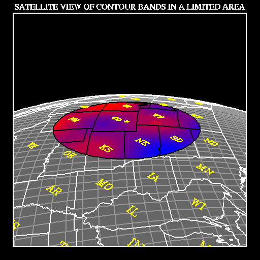
- Basic satellite-view projection:
R = SQRT(SA*SA-1)*SINA/(SA-COSA)
- where "SA" is the distance from the center of the earth to a
satellite above the point (PLAT,PLON), in multiples of the earth's
radius. Points for which COSA is less than "1/SA" are invisible.
The portion of the earth's surface which would be visible from
the satellite is projected inside a circle of radius 1. The center
of the projection is at the satellite's position. As the satellite
moves further and further out, the basic satellite-view projection
approaches the orthographic projection. See the examples named
"mpex05"
and "mpexfi".
- The basic satellite-view projection gives a view of the earth as
seen by a satellite camera that is looking straight down toward
the center of the earth. Note that the model for the "camera"
we're talking about here is a pin-hole camera, in which each
point of an image is formed by a single straight line emanating
from some point in the scene. Real cameras are more complicated
than that: each point of an image is formed by focusing infinitely
many rays emanating from a point in the scene (all the rays from
the point that happen to pass through the lens of the camera). An
image formed by a real camera is generally distorted in some
fashion and cannot be expected to exactly match an image formed
by our hypothetical pin-hole camera.
- See the examples named "mpex05" and
"mpexfi".
- General satellite-view projection:
R = (something messy that I don't have in closed form)!
- The user-settable parameters 'S1' and 'S2' affect the
satellite-view projection as follows: S1 measures the angle
between the line to the center of the earth and the line of sight
of the satellite (the line to which the projection plane is
perpendicular). The default value of S1 is zero, which gives the
basic satellite view. When S1 is non-zero, S2 specifies the angle
from the positive u axis of the basic satellite view
counter-clockwise to the line OP, where O is the origin of the
basic view and P is the projection (a single point), on the basic
view, of the desired line of sight from the satellite. When S1
and S2 are used, the part of the earth projected is the same as
for the basic view, but the part of the u/v plane covered by the
projection may become the interior of an ellipse, the area "inside"
a parabola, or the area "inside" one branch of a hyperbola; in
each of these cases, the major axis of the curve defining the limb
of the projection is at an angle S2 to the u axis.
- Basically, 'S1' and 'S2' allow you to aim the satellite camera in
any desired direction; however, getting exactly the view that you
want is not completely trivial. The example
"cpex10" demonstrates a technique that may
be quite useful: if, in the call to MAPROJ that requests the
satellite-view projection (with a first argument = 'SV' and
second and third arguments PLAT and PLON specifying the position
of the satellite), you use a value of ROTA (the final argument)
such that the point you want to aim the satellite camera at is
directly above the center of the basic view and you then use
'S1' non-zero and 'S2' = 90., you get a view with "outer space"
at the top, the earth at the bottom, and the horizon line more
or less horizontal. It is recommended that the satellite-view
projection be used with a call to MAPSET in which the first
argument JLTS = 'AN'; in that case, the other four arguments
specify the field of view of the camera (as angular distances
to the left, to the right, to the bottom, and to the top, of the
frame). It is further recommended that you not use a first
argument JLTS = 'MA' in such a call to MAPSET, since, in that case,
you get a view showing the entire part of the globe that is visible
from the satellite and distortion is likely to be extreme.
- See the examples named "mpex06" and
"cpex10". The latter is actually a CONPACK
example, but it demonstrates the aiming technique described in
the previous paragraph.
Cylindrical projections map the surface of the earth onto a cylinder
which is tangent to the earth along a great circle passing through the
user-specified point (PLAT,PLON) and tilted at a user-specified angle
ROTA. The cylinder is cut along a line parallel to its axis and unrolled
onto the plane. The cylindrical projections are generated as follows:
- Step 1: Imagine that the earth is placed behind the u/v plane so that
the point at latitude 0 and longitude 0 just touches the plane at the
point (0,0), the North Pole is at the top, and the South Pole is at
the bottom.
- Step 2: Rotate the earth about its polar axis until the v axis is
tangent to the meridian identified by PLON (and that meridian is
therefore closest to you).
- Step 3: Rotate the earth, tilting one of the poles directly toward
you and the other pole directly away from you, until the point
(PLAT,PLON) is at the origin of the u/v plane.
- Step 4: Rotate the earth clockwise through the angle ROTA about a
line perpendicular to the u/v plane and passing through the point
(0,0).
- Step 5: Wrap the u/v plane around the globe to form a cylinder, with
the u axis touching the earth along a great circle.
- Step 6: Using a technique dependent on the projection type, project
geographical outlines, parallels, and meridians outward from the
earth's surface onto the cylinder.
- Step 7: Cut the cylinder along a line parallel to its axis and
opposite the point (0,0).
- Step 8: Unwrap the cylinder again.
- Step 9: Set up linear scales along the u and v axes. The ranges of u
and v depend on the projection type.
- Step 10: Draw a rectangular or elliptical portion of the resulting
map.
What happens in step 6 above will be described for each of the three
types of cylindrical projections provided by EZMAP in the simple case
where PLAT, PLON, and ROTA are all zero. Let RLAT and RLON be the latitude
and longitude, in degrees, of a point to be projected; RLON must lie
between -180 and +180. (If PLAT, PLON, and/or ROTA are non-zero, one must
substitute for RLAT and RLON a pseudo-latitude and a pseudo-longitude
computed from the real latitude and longitude; this is left as an exercise
for the devotee of spherical trigonometry.) The cylindrical projections
may then be described as follows:
- Cylindrical Equidistant: U and V are computed using the equations
      U = RLON
      V = RLAT
- The entire globe is projected into a rectangle in the u/v plane. U
ranges from -180 to +180, V from -90 to +90.
- See the example named "mpex05".
- Mercator: U and V are computed using the equations
      U = RLON*pi/180 (where pi=3.14159...)
      V = ALOG(COT(45-RLAT/2))
- The entire globe is projected into an infinite rectangle in the
u/v plane. U ranges from -pi to +pi, V from -infinity to +infinity.
In practice, distortion becomes unacceptable for latitudes within
5 degrees of the North or South Pole.
- See the examples named "mpex03",
"mpex04",
"mpex05",
"mpex08", and
"mpex09".
- Mollweide-type: The projection is not a true Mollweide. U and V are
computed using the equations
      U = RLON/90
      V = COS(90-RLAT)
- The entire surface of the globe is projected into an ellipse. U
ranges from -2 to +2, V from -1 to +1.
- See the example named "mpex05".
This section describes all the user-callable routines of EZMAP. The
descriptions are arranged in alphabetical order.
The function MAPACI is normally used to pick colors for the areas created
by the boundary lines added to an area map by a call to MAPBLA. Note that
this function should not be used to select color indices for areas
defined by the new map database "Earth..1", which was created in 1998;
for that purpose, use EZMAPB functions instead (in particular, MPISCI).
Usage
The FORTRAN statement
ICLR = MAPACI(IAID)
where IAID is the the area identifier for one of the areas created by
the boundary lines in a selected outline dataset, gives ICLR an integer
value between 1 and 7. This integer value will normally be used (in a
manner determined by the user) to select a color index for that area.
It is guaranteed that, if two areas have a portion of their boundaries
of non-zero length in common, then MAPACI will return different values
for the two areas. For a complete list of area identifiers and the
values that MAPACI will return for each, see the section named
"AREA IDENTIFIERS".
See the example named "eezmpa".
Arguments
IAID (an input expression of type INTEGER) is an area
identifier for one of the areas defined by the set of boundary lines
added to an area map by a call to MAPBLA.
Adds to the area map in the array IAMA the set of boundary lines, of
projected geographical entities, determined by the current state of the
internal parameters of EZMAP. Note that this routine uses whichever old
outline dataset is selected by the value of the internal parameter 'OU';
to access the new map database "Earth..1", which was created in 1998, one
must call instead the EZMAPB routine MPLNAM (which see, below).
Usage
Execute the statement
CALL MAPBLA (IAMA)
to add boundary lines to the area map in the array IAMA. The area map
must previously have been initialized by calling the routine ARINAM, in
the package AREAS, using a statement like "CALL ARINAM (IAMA,LAMA)",
where LAMA is the length of the array IAMA. The area map may subsequently
be used in various ways; for example, one may call the AREAS routine
ARSCAM to draw a solid-filled map.
One or two groups of boundary lines are added to the area map by a call
to MAPBLA. The first, having group identifier 'G1' (default value 1),
consists of a perimeter (either rectangular or elliptical, depending on
the value of the internal parameter 'EL') and the set of projected
boundary lines implied by the user's selection of an outline dataset
(some combination of continental, U.S., and world political outlines).
For certain projections, a limb line may also be included.
If the parameter 'VS' has a value greater than zero, the group 'G2' is
added to the area map; it consists of a copy of the perimeter and the
limb line (if any) plus a set of vertical lines splitting the area
inside the perimeter into 'VS' vertical strips. (By default, the value
of 'VS' is 1.) The object of the group 'G2' is to split areas up,
reducing the number of points required to define a typical area below
the level at which some target hardware device begins to fail.
See the example named "eezmpa".
Arguments
IAMA (an input/output array of type INTEGER) is the area map
array to which boundary lines are to be added.
(The remaining arguments are IAAI, IAGI, NOGI, and ULPR.)
Draws geographical outlines masked by the contents of a specified area
map. Note that this routine uses whichever old outline dataset is selected
by the value of the internal parameter 'OU'; to access the new map database
"Earth..1", which was created in 1998, one must call instead the EZMAPB
routine MPLNDM (which see, below).
Usage
The FORTRAN statement
CALL MAPBLM (IAMA,XCRA,YCRA,MCRA,IAAI,IAGI,NOGI,ULPR)
is used to draw the set of boundary lines of projected geographical
entities determined by the current state of the internal parameters of
EZMAP, masked against the area map in the array IAMA.
MAPBLM is much like MAPLOT, except that the boundary lines are drawn
using calls to MAPITM and MAPIQM, which does the masking of the lines
against an area map and passes the pieces resulting from the masking
process along to a user-provided line-drawing routine.
See the example named "cpex10".
Arguments
IAMA (an input/output array of type INTEGER, dimensioned as
specified in a call to the AREAS routine ARINAM) is the array containing
the area map against which boundary lines are to be masked. The area map
must have been initialized by a call to ARINAM; it should contain the
edges required to create a desired effect. For example, an area map might
be created that defines a region of interest, within which user data is
available and within which boundary lines are to be drawn. For more
details, see the reference document for the package named
AREAS.
XCRA and YCRA (scratch arrays, dimensioned at least MCRA,
of type REAL) are to be used by MAPBLM in calls to the AREAS routine
ARDRLN; they will eventually be used in calls to the user-provided
line-processing routine ULPR.
MCRA (an input expression of type INTEGER) is the dimension of
the arrays XCRA and YCRA.
IAAI and IAGI (scratch arrays, dimensioned at least NOGI,
of type INTEGER) are to be used by MAPBLM in calls to the AREAS routine
ARDRLN; they will eventually be used in calls to the user-provided
line-processing routine ULPR. The mnemonics stand for "Integer Array
of Area Identifiers" and "Integer Array of Group Identifiers",
respectively.
NOGI (an input expression of type INTEGER) is the dimension of
the arrays IAAI and IAGI. The mnemonic stands for "Number Of Group
Identifiers (of edges in the area map)", which determines the required
dimension of IAAI and IAGI.
ULPR is the name of the user-supplied line-processing routine. It
must be declared EXTERNAL in the routine that calls MAPBLM, so that the
compiler and loader will know that it is the name of a routine to be
called instead of a variable. The user routine ULPR will be called once
for each piece of a boundary line resulting from the masking process; it
may decide to draw (or to not draw) each such piece. ULPR will be called
using a FORTRAN statement like
CALL ULPR (XCRA,YCRA,NCRA,IAAI,IAGI,NGPS)
where XCRA and YCRA are real arrays holding the normalized device
coordinates of NCRA points defining a polyline which is part of some
boundary line and IAAI and IAGI are integer arrays holding NGPS
area-identifier/group-identifier pairs for the area within which that
piece of the line lies. In writing ULPR, the user may rely upon a SET
call's having been done which makes it possible to use normalized device
coordinates in calls to routines like CURVE, CURVED, GPL, etc. For more
details, see the reference document for the package named
AREAS and, in particular, the
description of the subroutine ARDRLN.
Draws a complete map, as described by the current values of the internal
parameters of EZMAP. Note that this routine uses whichever old outline
dataset is selected by the value of the internal parameter 'OU'; to access
the new map database "Earth..1", which was created in 1998, one must call
instead the routines that MAPDRW would have called, but call MPLNDR (which
see, below) instead of MAPLOT.
Usage
Just call it. MAPDRW calls MAPINT (if the value of the internal parameter
'IN' indicates that initialization is required), MAPGRD, MAPLBL, and
MAPLOT, in that order.
Users may sometimes wish to call directly the routines that MAPDRW calls.
For example, they sometimes want to change the aspect ratio of a map
drawn by EZMAP to something other than that implied by the projection
selected; in order to do this, it is necessary to put calls to GETSET
and SET in between the call to MAPINT and the calls to MAPGRD, MAPLBL,
and MAPLOT. This is possible only if the user is calling those routines
directly (rather than indirectly, by calling MAPDRW).
See the examples named "mpex01",
"mpex02", "mpex04",
"mpex05", "mpex06",
"mpex07", and "mpex10".
Arguments
None.
To examine each outline-dataset segment.
Usage
MAPEOD is called by MAPLOT to examine each segment in an outline dataset
just before it is plotted and by MAPBLA to examine each segment in an
outline dataset just before it is added to an area map. The default
version of MAPEOD does nothing. A user-supplied version may cause
selected segments to be deleted (to reduce the clutter in northern
Canada, for example). Note that this routine is not called by any of the
EZMAPB routines; for the same purpose, they call the routine MPCHLN.
See the examples named "mpex03",
"mpex05", and "mpex09".
Arguments
NOUT (an input expression of type INTEGER) is the number of the
outline dataset from which the segment comes, as follows:
| NOUT | Dataset from which the segment
came |
| 1 | 'CO' - Continental outlines only. |
| 2 | 'US' - U.S. state outlines only. |
| 3 | 'PS' - Continental, U.S. state, and international outlines. |
| 4 | 'PO' - Continental and international outlines. |
NSEG (an input expression of type INTEGER) is the number of the
segment within the outline dataset. The maps in the example named
"mpex09" show segment numbers for the outline
dataset 'CO'; the program may be modified to produce maps showing segment
numbers for any outline dataset.
IDLS and IDRS (input expressions of type INTEGER) are
identifiers for the areas to the left and right, respectively, of the
segment. (Left and right are defined from the standpoint of a viewer
standing at point 1 of the segment and looking toward point 2.) For a
complete list of area identifiers, see the section named
"AREA IDENTIFIERS".
NPTS (an input/output variable of type INTEGER), on entry, is
the number of points defining the outline segment. NPTS may be zeroed
by MAPEOD to suppress any use of the segment on the map.
PNTS (an input/output array, dimensioned 2*NPTS, of type REAL)
is an array of coordinates. PNTS(1) and PNTS(2) are the latitude and
longitude of the first point, PNTS(3) and PNTS(4) the latitude and
longitude of the second point, ... PNTS(2*NPTS-1) and PNTS(2*NPTS)
the latitude and longitude of the last point. All values are in degrees.
Longitudes are all between -180 and +180; no segment crosses the meridian
at -180 (+180) degrees.
Draws lines on a map - used in conjunction with MAPVEC.
Usage
The statement
CALL MAPFST (RLAT,RLON)
is equivalent to the statement
CALL MAPIT (RLAT,RLON,0)
See the description of MAPIT.
Arguments
RLAT and RLON (input expressions of type REAL) are defined
in the same way as for MAPIT (which see).
Calculates the latitudes and longitudes of points on the shortest great
circle route between two given points on the surface of the globe.
Usage
The statement
CALL MAPGCI (ALAT,ALON,BLAT,BLON,NOPI,RLTI,RLNI)
defines the positions of two points, A and B, on the globe and the number
of equally-spaced points, NOPI, to be interpolated along the great circle
route from A to B. The latitudes and longitudes of the interpolated
points are returned to the caller in the arrays RLTI and RLNI. If the
points A and B are exactly opposite one another on the globe, the code
does not fail, but the direction of the great circle route will be
somewhat unpredictable (since, in that case, there is more than one
great circle route joining the two points).
Arguments
ALAT and ALON (input expressions of type REAL) specify the
latitude and longitude of the point A.
BLAT and BLON (input expressions of type REAL) specify
the latitude and longitude of the point B.
NOPI (an input expression of type INTEGER) specifies the number of
equally-spaced points to be interpolated along the great circle from A to
B.
RLTI and RLNI (output arrays of type REAL, each dimensioned
at least NOPI) are the latitudes and longitudes of the interpolated
points. Each lat/lon pair defines one of the interpolated points; the
points are in order of increasing distance from A. The positions of the
points A and B themselves are not returned in these arrays; only the
positions of the interpolated points are.
Draws a lat/lon grid.
Usage
The statement
CALL MAPGRD
draws a grid consisting of lines of latitude (parallels) and lines of
longitude (meridians). If EZMAP needs initialization or if there is an
uncleared NCAR Graphics error or if the parameter 'GR' is less than or
equal to zero, MAPGRD does nothing. The values of the parameters 'GP',
'GN', and 'GT' also affect the drawing of the grid.
The grid is drawn using calls to MAPIT and MAPIQ. By default, MAPGRD
forces the value of the internal parameter 'DL' to zero, so that the
grid will be drawn using calls to the routines FRSTD and VECTD, in the
dash package. MAPGRD also calls the dash-package routine DASHDB to force
the current dash pattern to the value specified by the internal parameter
'DA'. Before returning control to the user, MAPGRD restores the original
value of 'DL' and the original dash pattern. A user version of the
routine MAPUSR may be supplied to change the way in which the grid
lines are drawn (as shown in the example
"mpex09").
Arguments
None.
(The remaining arguments are IAAI, IAGI, NOGI, and ULPR.)
Draws lines of latitude and longitude masked against an existing area
map. The example "eezmpa" described in the section
"EXAMPLES" shows how MAPGRM may be used to
limit the drawing of these lines to areas over ocean, but there are other
possible uses.
Usage
The FORTRAN statement
CALL MAPGRM (IAMA,XCRA,YCRA,MCRA,IAAI,IAGI,NOGI,ULPR)
is used to draw lines of latitude and longitude masked against the
existing area map in the array IAMA.
MAPGRM is just like MAPGRD, except that the grid lines are drawn using
calls to MAPITM and MAPIQM, which does the masking of the lines against
an area map and passes the pieces resulting from the masking process
along to a user-provided line-drawing routine.
See the examples named "eezmpa",
"tezmpa", and "tezmpb".
Arguments
IAMA (an input/output array, dimensioned as specified in a call
to the AREAS routine ARINAM, of type INTEGER) is the array containing
the area map against which lines of latitude and longitude are to be
masked. The area map must have been initialized by a call to ARINAM; it
may contain edges added to it by calling MAPBLA, as is the case in the
example named "eezmpa", or it may contain a
different set of edges to create some other desired effect. For example,
an area map might be created that defines a region of interest, within
which user data is available and within which lines of latitude and
longitude are to be drawn. For more details, see the reference document
for the package named AREAS.
XCRA and YCRA (scratch arrays, dimensioned at least MCRA,
of type REAL) are to be used by MAPGRM in calls to the AREAS routine
ARDRLN; they will eventually be used in calls to the user-provided
line-processing routine ULPR.
MCRA (an input expression of type INTEGER) is the dimension of
the arrays XCRA and YCRA.
IAAI and IAGI (scratch arrays, dimensioned at least NOGI,
of type INTEGER) are to be used by MAPGRM in calls to the AREAS routine
ARDRLN; they will eventually be used in calls to the user-provided
line-processing routine ULPR. The mnemonics stand for "Integer Array
of Area Identifiers" and "Integer Array of Group Identifiers",
respectively.
NOGI (an input expression of type INTEGER) is the dimension of
the arrays IAAI and IAGI. The mnemonic stands for "Number Of Group
Identifiers (of edges in the area map)", which determines the required
dimension of IAAI and IAGI.
ULPR is the name of the user-supplied line-processing routine. It
must be declared EXTERNAL in the routine that calls MAPGRM, so that the
compiler and loader will know that it is the name of a routine to be
called instead of a variable. The user routine ULPR will be called once
for each piece of a latitude/longitude line resulting from the masking
process; it may decide to draw (or to not draw) each such piece. ULPR
will be called using a FORTRAN statement like
CALL ULPR (XCRA,YCRA,NCRA,IAAI,IAGI,NGPS)
where XCRA and YCRA are real arrays holding the normalized device
coordinates of NCRA points defining a polyline which is part of some
latitude/longitude line and IAAI and IAGI are integer arrays holding
NGPS area-identifier/group-identifier pairs for the area within which
that piece of the line lies. In writing ULPR, the user may rely upon
a SET call's having been done which makes it possible to use normalized
device coordinates in calls to routines like CURVE, CURVED, GPL, etc.
For more details, see the reference document for the package named
AREAS and, in particular, the
description of the subroutine ARDRLN.
Gets the current value of a specified EZMAP parameter. An alternate name,
more nearly consistent with those used in other NCAR Graphics packages,
is provided for this routine.
Usage
Use one of the four statements
      CALL MAPGTC (PNAM,CVAL) or CALL MPGETC (PNAM,CVAL)
      CALL MAPGTI (PNAM,IVAL) or CALL MPGETI (PNAM,IVAL)
      CALL MAPGTL (PNAM,LVAL) or CALL MPGETL (PNAM,LVAL)
      CALL MAPGTR (PNAM,RVAL) or CALL MPGETR (PNAM,RVAL)
depending on whether the value to be retrieved is of type CHARACTER,
INTEGER, LOGICAL, or REAL. The values of some parameters may be retrieved
in more than one way. For example, the value of the initialization flag
may be retrieved as a logical quantity (.TRUE. or .FALSE.) or as an
integer (non-zero or zero).
See the examples named "mpex07" and
"mpex08".
Arguments
PNAM (an input expression of type CHARACTER) specifies the name
of the parameter to get. Only the first two characters of the string are
examined. See the section "INTERNAL PARAMETERS"
for a list of all the internal parameters whose values may be
retrieved.
xVAL (an output variable of type CHARACTER, INTEGER, LOGICAL,
or REAL, depending on which routine is called) receives the value of
the parameter specified by PNAM.
Initialization.
Usage
The statement
CALL MAPINT
initializes the EZMAP package. This is required initially and again
after a call to any of the routines MAPPOS, MAPROJ, or MAPSET. The
flag 'IN', which may be retrieved by a call to MAPGTI or MAPGTL,
indicates whether or not initialization is required at a given time.
As of now (April, 1987), no parameter change by means of a call to
MAPSTx forces re-initialization; only calls to MAPPOS, MAPROJ, and
MAPSET do.
To clarify the use of MAPINT: Once the internal parameters describing
a map transformation are completely defined, MAPINT must be called; it
computes as many of the transformation parameters as possible, so that,
when MAPTRN is called, it can return the u/v coordinates corresponding
to a particular lat/lon position as quickly as possible. If the
transformation is changed, MAPINT must be re-called before the next
call to MAPTRN. Routines which call MAPTRN and therefore depend on
MAPINT's having been called are as follows: MAPBLA, MAPFST, MAPGRD,
MAPGRM, MAPIQ, MAPIQA, MAPIQM, MAPIT, MAPITA, MAPITM, MAPLBL, MAPLOT,
MAPTRA, MAPTRI, MAPVEC, MPLNAM, MPLNDM, MPLNDR, and SUPCON. Routines
which change the transformation in some way and therefore require MAPINT
to be re-called are as follows: MAPPOS, MAPROJ, and MAPSET. If one is
just doing a single plot, one does the parameter-setting calls that
define the transformation, calls MAPINT to initialize, and then calls
the various routines that draw the plot; in this case, a single call
to MAPINT is all that is necessary.
One of the things that MAPINT does is call the SPPS routine SET to define
the mapping from the u/v (projection) plane to the x/y (plotter) plane,
so that u/v coordinates returned by the routines MAPTRA and MAPTRN can
be used directly (as "user" coordinates) in calls to other NCAR Graphics
routines. The user must be careful not to interfere with this process by
doing an inappropriate call to SET in between calling MAPINT and calling
other routines that depend on the proper SET call's having been done; if
such a call must be done, the routine MAPRS (q.v.) may be used to restore
the SET call done by MAPINT.
See the examples named "mpex09",
"mpex10", and "eezmpa".
Arguments
None.
Terminate a string of calls to MAPIT.
Usage
The statement
CALL MAPIQ
flushes MAPIT's buffers. It is particularly important that this be
done before a STOP or a CALL FRAME and before changing the color index,
dash pattern, etc.
See the description of MAPIT, below.
See the example named "mpexfi".
Arguments
None.
Terminate a string of calls to MAPITA.
Usage
The statement
CALL MAPIQA (IAMA,IGID,IAIL,IAIR)
flushes MAPITA's buffers. It is particularly important that this be
done before attempting to use the area map in the array IAMA for
something.
See the description of MAPITA, below.
See the example named "cpex08", which
is descibed in the reference document for the package named
CONPACK.
Arguments
IAMA, IGID, IAIL, and IAIR are all as
described for the routine MAPITA (described below).
Terminate a string of calls to MAPITD.
Usage
The statement
CALL MAPIQD
flushes MAPITD's buffers. It is particularly important that this be
done before a STOP or a CALL FRAME and before changing the color index,
dash pattern, etc.
See the description of MAPITD, below.
Arguments
None.
(The remaining arguments are IAAI, IAGI, NOGI, and ULPR.)
Terminates a string of calls to the routine MAPITM.
Usage
The statement
CALL MAPIQM (IAMA,XCRA,YCRA,MCRA,IAAI,IAGI,NOGI,ULPR)
flushes MAPITM's buffers. It is particularly important that this be
done before a STOP, a CALL FRAME, or a call to change line color, width,
dash pattern, etc.
See the description of MAPITM, below.
There is currently no example available for the routine MAPIQM.
Arguments
IAMA, XCRA, YCRA, MCRA, IAAI,
IAGI, NOGI, and ULPR are all as described for
the routine MAPITM (described below).
Draws lines on a map.
Usage
MAPIT is used to draw lines on a map; it is called by various EZMAP
routines (MAPLOT, MAPGRD, MAPVEC, and MPLNDR) and may also be called
directly by the user. MAPIT attempts to omit non-visible portions of
lines and to handle "cross-over" - a jump from one end of the map to
the other caused by the projection's having slit the globe along some
half of a great circle and laid it open with the two sides of the slit
at opposite ends of the map. Cross-over can occur on cylindrical and
conical projections; MAPIT handles it gracefully on the former and not
quite so well on the latter.
The EZMAP parameter 'DL' determines whether MAPIT draws solid lines or
dotted lines. Dotted lines are drawn using calls to POINTS. Solid lines
are drawn using calls to DASHD, FRSTD, and VECTD. The EZMAP parameters
'DD' and 'MV' also affect MAPIT's behavior. See the description of these
parameters in the section
"INTERNAL PARAMETERS".
A sequence of calls to MAPIT should be followed by a call to MAPIQ (which
see, above) to flush its buffers before a STOP, a CALL FRAME, or a call
to change the color index, line width, dash pattern, or the like.
Beware of intermingling calls to MAPIT and calls to MAPITD; the two
routines share buffer space and intermingling the calls will have
undesirable effects.
Because the entire line segment joining the points in two contiguous
pen-down calls to MAPIT is considered visible if both of the points are
visible and invisible if both of the points are invisible, such points
should not be too far apart on the globe.
See the example named "mpexfi".
Arguments
RLAT and RLON (input expressions, of type REAL) specify the
latitude and longitude of a point to which the "pen" is to be moved. Both
are given in degrees. RLAT must be between -90. and +90., inclusive; RLON
must be between -540. and +540., inclusive.
IFST (an input expression, of type INTEGER) is 0 to do a "pen-up"
move, 1 to do a "pen-down" move only if the distance from the last point
to the new point is greater than 'MV' plotter units, and 2 or greater to
do a "pen-down" move regardless of the distance from the last point to
the new one.
Usage
The routines MAPITA and MAPIQA may be used to add lines defined by a set
of user-specified latitudes and longitudes to an area map; they attempt
to omit non-visible portions of lines and to handle "cross-over", in the
same way that MAPIT does.
MAPITA is called like the EZMAP routine MAPIT (which see, above) but has
some additional arguments:
CALL MAPITA (RLAT,RLON,IFST,IAMA,IGID,IAIL,IAIR)
Additional arguments are the area map array IAMA, a group identifier IGID, and left and right area identifiers IAIL and IAIR. MAPIQA is called like the EZMAP routine MAPIQ, to terminate a series of calls to MAPITA and to flush the buffers; it has the same additional arguments:
CALL MAPIQA (IAMA,IGID,IAIL,IAIR)
The additional arguments are passed by MAPITA and MAPIQA to the routine
AREDAM, in the package named AREAS,
for which a reference document is available.
See the example named "cpex08", which
is described in the reference document for the package named
CONPACK.
Arguments
RLAT and RLON (input expressions, of type REAL) specify
the latitude and longitude of a point to which the "pen" is to be moved.
Both are given in degrees. RLAT must be between -90. and +90., inclusive;
RLON must be between -540. and +540., inclusive.
IFST (an input expression, of type INTEGER) is 0 to do a "pen-up"
move, 1 to do a "pen-down" move only if the distance from the last point
to the new point is greater than 'MV' plotter units, and 2 or greater to
do a "pen-down" move regardless of the distance from the last point to
the new one.
IAMA (an input/output array of type INTEGER, dimensioned as
specified in a call to the AREAS initialization routine ARINAM) is the
area map to which lines in MAPITA's buffer are to be added.
IGID (an input expression of type INTEGER) is the group identifier
to be passed to the AREAS routine AREDAM when the lines in MAPITA's
buffer are added to the area map in IAMA.
IAIL (an input expression of type INTEGER) is the left area
identifier to be passed to the AREAS routine AREDAM when the lines in
MAPITA's buffer are added to the area map in IAMA.
IAIR (an input expression of type INTEGER) is the right area
identifier to be passed to the AREAS routine AREDAM when the lines in
MAPITA's buffer are added to the area map in IAMA.
Draws lines on a map using the new dash package DASHPACK.
Usage
MAPITD is used to draw lines on a map; it is not called by any of the
EZMAP routines, but is intended to be called directly by the user.
MAPITD is just like MAPIT except that it uses the new dash package
DASHPACK instead of the old DASHCHAR; it attempts to omit non-visible
portions of lines and to handle "cross-over" - a jump from one end of
the map to the other caused by the projection's having slit the globe
along some half of a great circle and laid it open with the two sides
of the slit at opposite ends of the map. Cross-over can occur on
cylindrical and conical projections; MAPITD handles it gracefully on
the former and not quite so well on the latter.
The EZMAP parameter 'DL' determines whether MAPITD draws solid lines
or dotted lines. Dotted lines are drawn using calls to POINTS. Solid
lines are drawn using calls to DPFRST, DPVECT, and DPLAST. The EZMAP
parameters 'DD' and 'MV' also affect MAPITD's behavior. See the
descriptions of these parameters in the section
"INTERNAL PARAMETERS".
A sequence of calls to MAPITD should be followed by a call to MAPIQD
(which see, above) to flush its buffers before a STOP, a CALL FRAME,
or a call to change the color index, line width, dash pattern, or the
like.
Beware of intermingling calls to MAPIT and calls to MAPITD; the two
routines share buffer space and intermingling the calls will have
undesirable effects.
Because the entire line segment joining the points in two contiguous
pen-down calls to MAPITD is considered visible if both of the points
are visible and invisible if both of the points are invisible, such
points should not be too far apart on the globe.
Arguments
RLAT and RLON (input expressions, of type REAL) specify
the latitude and longitude of a point to which the "pen" is to be moved.
Both are given in degrees. RLAT must be between -90. and +90., inclusive;
RLON must be between -540. and +540., inclusive.
IFST (an input expression, of type INTEGER) is 0 to do a "pen-up"
move, 1 to do a "pen-down" move only if the distance from the last point
to the new point is greater than 'MV' plotter units, and 2 or greater to
do a "pen-down" move regardless of the distance from the last point to
the new one.
(The remaining arguments are IAAI, IAGI, NOGI, and ULPR.)
Usage
The routines MAPITM and MAPIQM may be used to draw lines defined by a
set of user-specified latitudes and longitudes on a map, masked by the
areas defined by an area map (perhaps one created by a call to MAPBLA
or perhaps one created by a set of calls to routines in the package
AREAS); like MAPIT and MAPIQ, they attempt to omit non-visible portions
of lines and to handle "cross-over".
MAPITM is called like the EZMAP routine MAPIT (which see, above) but
has some additional arguments:
CALL MAPITM (RLAT,RLON,IFST,IAMA,XCRA,YCRA,MCRA,IAAI,IAGI,NOGI,ULPR)
Additional arguments are the area-map array IAMA, coordinate arrays
XCRA and YCRA, dimensioned MCRA, integer arrays IAAI and IAGI,
dimensioned NOGI, and a user-provided line-processing routine named
ULPR. MAPIQM is called like the EZMAP routine MAPIQ, to terminate
a series of calls to MAPITM and to flush the buffers; it has the same
additional arguments:
CALL MAPIQM (IAMA,XCRA,YCRA,MCRA,IAAI,IAGI,NOGI,ULPR)
The additional arguments are passed by MAPITM and MAPIQM to the routine
ARDRLN, in the package named AREAS,
for which a reference document is available.
No example is currently available for MAPITM.
Arguments
RLAT and RLON (input expressions, of type REAL) specify
the latitude and longitude of a point to which the "pen" is to be moved.
Both are given in degrees. RLAT must be between -90. and +90., inclusive;
RLON must be between -540. and +540., inclusive.
IFST (an input expression, of type INTEGER) is 0 to do a "pen-up"
move, 1 to do a "pen-down" move only if the distance from the last point
to the new point is greater than 'MV' plotter units, and 2 or greater to
do a "pen-down" move regardless of the distance from the last point to
the new one.
IAMA (an input/output array of type INTEGER, dimensioned as
specified in a call to the AREAS initialization routine ARINAM) is the
array containing the area map against which lines drawn by MAPIQM will
be masked.
XCRA and YCRA (scratch arrays of type REAL, each
dimensioned MCRA) are to be passed by MAPIQM to the AREAS routine ARDRLN,
which uses them in calls to the user line-processing routine ULPR. They
will hold the X and Y coordinates of points in the fractional coordinate
system defining some portion of the projection of a user-defined polyline
on the globe.
MCRA (an input expression of type INTEGER) is the size of each of
the arrays XCRA and YCRA. The value of MCRA must be at least two. For
most applications, the value 100 works nicely.
IAAI and IAGI (scratch arrays of type INTEGER, each
dimensioned NOGI) are to be passed by MAPIQM to the AREAS routine ARDRLN,
which uses them in calls to the user line-processing routine ULPR. They
will hold area identifier/group identifier pairs for the area containing
the polyline fragment defined by XCRA and YCRA.
NOGI (an input expression of type INTEGER) is the size of each
of the arrays IAAI and IAGI. The value of NOGI must be greater than or
equal to the number of groups of edges placed in the area map in IAMA.
ULPR is the name of a user-provided line-processing routine. This
name must appear in an EXTERNAL statement in the routine that calls
MAPITM, so that the compiler and loader will know that it is the name
of a routine to be called, rather than the name of a variable.
Labels the map.
Usage
The statement
CALL MAPLBL
if the parameter 'LA' is set appropriately, labels the international
date line (ID), the equator (EQ), the Greenwich Meridian (GM), and the
poles (NP and SP), and, if the parameter 'PE' is set appropriately,
draws the perimeter of the map. If EZMAP needs initialization or if
there is an uncleared NCAR Graphics error, MAPLBL does nothing.
See the example named "eezmpa".
Arguments
None.
Draws geographical outlines. Note that this routine uses whichever old
outline dataset is selected by the value of the internal parameter 'OU';
to access the new map database "Earth..1", which was created in 1998, one
must call instead the EZMAPB routine MPLNDR (which see, below).
Usage
The statement
CALL MAPLOT
draws the continental and/or international and/or U.S. state outlines
selected by the EZMAP parameter 'OU'; the parameter 'DO' determines
whether solid lines or dotted lines are used. If EZMAP currently needs
initialization or if there is an uncleared NCAR Graphics error, MAPLOT
does nothing.
The outlines are drawn using calls to MAPIT and MAPIQ. By default,
MAPLOT forces the value of the internal parameter 'DL' equal to the
value of the internal parameter 'DO'; it also supplies the dash package
with a solid-line dash pattern. When 'DO' is zero, the outlines are
drawn using calls to the routines FRSTD and VECTD, in the dash package,
and this gives solid lines. When 'DO' is non-zero, the outlines are
drawn using calls to the SPPS routine POINTS, which gives dotted lines.
Before returning control to the user, MAPLOT restores the original value
of 'DL' and the original dash pattern. A user version of the routine
MAPUSR may be supplied to change the way in which the outlines are
drawn (as shown in the example "mpex09").
See the examples named "mpex09" and
"eezmpa".
Arguments
None.
Positions the map on the plotter frame.
Usage
The statement
CALL MAPPOS (XLOW,XROW,YBOW,YTOW)
sets four EZMAP parameters specifying the position of a window in the
plotter frame within which maps are to be drawn. Each of the arguments
is between 0. and 1., inclusive, and specifies the position of one edge
of the window, as a fraction of the distance from left to right, or from
bottom to top, across the window. The map is centered within the window
and made as large as possible, but maintains its intrinsic shape (aspect
ratio).
If it is desired to give a map a different aspect ratio than that implied
by the projection being used, it will be necessary to insert, immediately
after the call to MAPINT, an appropriate call to SET to override the one
done by MAPINT and therefore to specify precisely the mapping of the u/v
plane into a desired viewport on the plotter frame. Typically, one might
call GETSET to find out what arguments 5-8 should be in one's own call
to SET. Note that, if MAPDRW is being called, that call will have to be
replaced by calls directly to MAPINT, MAPGRD, MAPLBL, and MAPLOT, in
order to allow one's own call to SET to be placed immediately after the
call to MAPINT.
See the examples named "mpex04",
"mpex05", "mpex06", and
"mpex07".
Arguments
XLOW (an input expression, of type REAL) specifies the position
of the left edge of the window. The default is .05.
XROW (an input expression, of type REAL) specifies the position
of the right edge of the window. The default is .95.
YBOW (an input expression, of type REAL) specifies the position
of the bottom edge of the window. The default is .05.
YTOW (an input expression, of type REAL) specifies the position
of the top edge of the window. The default is .95.
Set the projection to be used.
Usage
The statement
CALL MAPROJ (JPRJ,PLAT,PLON,ROTA)
sets EZMAP parameters specifying the projection to be used for subsequent
maps.
See the examples named "mpex01",
"mpex02", "mpex04",
"mpex05", "mpex06",
"mpex07", "mpex09",
"mpex10", and "eezmpa".
Arguments
JPRJ (an input expression, of type CHARACTER) defines the desired
projection type. All the possible values are two characters in length;
these are the possibilities:
The conic projection:
- 'LC' - Lambert conformal conic with two standard parallels.
The azimuthal projections:
- 'ST' - Stereographic.
- 'OR' - Orthographic. The EZMAP parameter 'SA' will be
zeroed. See the note below.
- 'LE' - Lambert equal area.
- 'GN' - Gnomonic.
- 'AE' - Azimuthal equidistant.
- 'SV' - Satellite-view. If the EZMAP parameter 'SA' is less
than or equal to 1., it will be reset to 6.631 (the
value for a satellite in a geosynchronous orbit). See
the note below.
The cylindrical projections:
- 'CE' - Cylindrical equidistant.
- 'ME' - Mercator.
- 'MO' - Mollweide-type.
Note: The orthographic and satellite-view projections have the same
internal identifier. The EZMAP parameter 'SA' determines which will be
used. If a call to MAPROJ selecting one or the other is followed by a
call to MAPSTR resetting 'SA', it may have the effect of causing the
other to be used. See the description of 'SA', below, in the description
of the routine MAPSTx.
PLAT, PLON, and ROTA (input expressions, of type REAL) are
angular quantities, in degrees. How they are used depends on the value
of JPRJ, as follows:
- If JPRJ is not equal to 'LC': PLAT and PLON define the latitude and
longitude of the pole of the projection - the point on the globe
which is to project to the origin of the u/v plane. PLAT must be
between -90. and +90., inclusive, positive in the northern hemisphere,
negative in the southern. PLON must be between -180. and +180.,
inclusive, positive to the east, and negative to the west, of
Greenwich. ROTA is the angle between the v axis and north at the
origin. It is taken to be positive if the angular movement from
north to the v axis is counter-clockwise, negative otherwise. If
the origin is at the north pole, "north" is considered to be in the
direction of PLON+180. If the origin is at the south pole, "north"
is considered to be in the direction of PLON. For the cylindrical
projections, the axis of the projection is parallel to the v axis.
- If JPRJ is equal to 'LC': PLON defines the central meridian of the
projection, and PLAT and ROTA define the two standard parallels. If
PLAT and ROTA are equal, a simpler conic projection, with one
standard parallel, is used.
For more detailed descriptions of the projections, see the section
named "PROJECTIONS".
Re-calls SET.
Usage
The statement
CALL MAPRS
repeats the SET call last done by the routine MAPINT. This might be used
when user lines are to be plotted over a map generated in a different
overlay (e.g., using a flash buffer), and when the system plot package
does not reside in an outer overlay.
No example is available for MAPRS.
Arguments
None.
Restores the state of EZMAP saved by an earlier call to MAPSAV.
Usage
The statement
CALL MAPRST (IFNO)
restores EZMAP to a previously saved state (frequently the default state)
by reading, from the unit specified by IFNO, values of all user-settable
parameters, and then executing MAPINT.
No example is available for MAPRST.
Arguments
IFNO (an input expression, of type INTEGER) is the number of a
unit from which a single unformatted record is to be read. It is the
user's responsibility to position this unit. MAPRST does not rewind it,
either before or after reading the record.
Saves the current state of EZMAP for later restoration by MAPRST.
Usage
The statement
CALL MAPSAV (IFNO)
saves the current state of EZMAP (frequently the default state) by
writing, on the unit specified by IFNO, the current values of all the
user-settable parameters.
No example is available for MAPSAV.
Arguments
IFNO (an input expression, of type INTEGER) is the number of a
unit to which a single unformatted record is to be written. It is the
user's responsibility to position this unit. MAPSAV does not rewind it,
either before or after writing the record.
To specify the rectangular portion of the u/v plane to be drawn.
Usage
The statement
CALL MAPSET (JLTS,PLM1,PLM2,PLM3,PLM4)
specifies what portion of the u/v plane is to be plotted.
See the examples named "mpex01",
"mpex02", "mpex04",
"mpex07", "mpex09",
"mpex10", and "eezmpa".
Arguments
JLTS (an input expression, of type CHARACTER) is a character
string specifying how the limits of the map are to be chosen. There are
five possibilites, as follows:
- JLTS='MA' (MAXIMUM). The maximum useful area produced by the
projection is plotted. PLM1, PLM2, PLM3, and PLM4 are not used.
- JLTS='CO' (CORNERS). The points (PLM1,PLM2) and (PLM3,PLM4) are to
be at opposite corners of the map. PLM1 and PLM3 are latitudes, in
degrees. PLM2 and PLM4 are longitudes, in degrees. If a cylindrical
projection is being used, the first point should be on the left edge
of the map and the second point on the right edge; otherwise, the
order makes no difference. Note that, even though the specified
points will be at the corners of the map, you are not guaranteed
that a point having a latitude between PLM1 and PLM3 and a longitude
between PLM2 and PLM4 will be on the map; if that is what you want,
you should use the "GRID" option, described below.
- JLTS='PO' (POINTS). PLM1, PLM2, PLM3, and PLM4 are two-element
arrays giving the latitudes and longitudes, in degrees, of four
points which are to be on the edges of the rectangular map. If a
cylindrical projection is being used, the first point should be on
the left edge and the second point on the right edge; otherwise, the
order makes no difference.
- JLTS='AN' (ANGLES). PLM1, PLM2, PLM3, and PLM4 are positive angles,
in degrees, representing angular distances from a point on the map
to the left, right, bottom, and top edges of the map, respectively.
For most projections, these angles are measured with the center of
the earth at the vertex and represent angular distances from the
point which projects to the origin of the u/v plane; on a
satellite-view projection, they are measured with the satellite at
the vertex and represent angular deviations from the line of sight.
Angular limits are particularly useful for polar projections and for
the satellite-view projection; they are not appropriate for the
Lambert conformal conic and an error will result if one attempts
to use JLTS='AN' with JPRJ='LC'.
- JLTS='LI' (LIMITS). PLM1, PLM2, PLM3, and PLM4 specify the minimum
value of u, the maximum value of u, the minimum value of v, and the
maximum value of v, respectively. Knowledge of the projection
equations is necessary in order to use this option correctly.
- JLTS='GR' (GRID). PLM1, PLM2, PLM3, and PLM4 specify a minimum
latitude, a minimum longitude, a maximum latitude, and a maximum
longitude, in degrees. The map limits will be set up in such a way
that an entire "grid" of data in the area defined by these limits
will be visible on the map.
PLM1, PLM2, PLM3, and PLM4 (input arrays, dimensioned 2,
of type REAL) are as described above, depending on the value of JLTS.
Note that each is a two-element array. Strictly speaking, the FORTRAN
standard requires that they be declared as such, even when only the
first element of each array is used.
To set the values of certain EZMAP parameters. An alternate name, more
nearly consistent with those used in other NCAR Graphics packages, is
provided for this routine
Usage
Use one of the four statements
      CALL MAPSTC (PNAM,CVAL) or CALL MPSETC (PNAM,CVAL)
      CALL MAPSTI (PNAM,IVAL) or CALL MPSETI (PNAM,IVAL)
      CALL MAPSTL (PNAM,LVAL) or CALL MPSETL (PNAM,LVAL)
      CALL MAPSTR (PNAM,RVAL) or CALL MPSETR (PNAM,RVAL)
depending on whether the value to be set is of type CHARACTER, INTEGER,
LOGICAL, or REAL. Some parameters may be set in more than one way. For
example, the parameter 'GR', which specifies the grid spacing, may be
given the value 10.0 in either of two ways:
      CALL MAPSTI ('GR',10)
      CALL MAPSTR ('GR',10.)
The flag which controls dotting of outlines may be turned on using either
of these calls:
      CALL MAPSTI ('DO',1)
      CALL MAPSTL ('DO',.TRUE.)
The important point to remember is that the last character of the routine
name implies the type of its second argument.
See the examples named "mpex01",
"mpex02", "mpex04",
"mpex05", "mpex06",
"mpex07", "mpex08",
"mpex09", "mpex10",
"mpexfi", and "eezmpa".
Arguments
PNAM (an input expression, of type CHARACTER*2) specifies the
name of an internal parameter whose value is to be set. Only the first
two characters of this string are examined.
xVAL (an input expression of type CHARACTER, INTEGER, LOGICAL,
or REAL, depending on which routine is called) contains the value to
be given to the parameter specified by PNAM.
See the section "INTERNAL PARAMETERS" for
descriptions of all the internal parameters.
To project points.
MAPTRA is just like MAPTRN except that, if a point being projected is
outside the boundary of the map (as defined by the last call to MAPSET
and by the value of the internal parameter 'EL'), a special value is
returned to signal this condition; see the sub-section named "Arguments",
below. (The default version of the CONPACK routine named CPMPXY now calls
MAPTRA, rather than MAPTRN; it was for this purpose that MAPTRA was created,
but users may wish to call it, as well.)
Usage
The statement
CALL MAPTRA (RLAT,RLON,UVAL,VVAL)
is used to find the projection in the u/v plane of a point whose latitude
and longitude are known. MAPTRA may be called at any time after EZMAP has
been initialized (by calling MAPINT or otherwise).
Currently, no example is available for MAPTRA.
Arguments
RLAT and RLON (input expressions, of type REAL) are the
latitude and longitude, respectively, of a point on the globe. RLAT
must be between -90. and +90., inclusive; RLON must be between -540.
and +540., inclusive.
UVAL and VVAL (output variables, of type REAL) define
the point (UVAL,VVAL) that is the projection in the u/v plane of
(RLAT,RLON). The units of UVAL and VVAL depend on the projection.
If the point is not projectable or if it is outside the boundary of
the map, as defined by the last call to MAPSET and by the value of the
parameter 'EL', UVAL is returned equal to 1.E12.
To perform inverse transformations.
Usage
The statement
CALL MAPTRI (UVAL,VVAL,RLAT,RLON)
is used to find the latitude and longitude of a point whose projection
in the u/v plane is known. MAPTRI may be called at any time after EZMAP
has been initialized (by calling MAPINT or otherwise).
See the example named "mpex10".
Arguments
UVAL and VVAL (input expressions, of type REAL) define the
point (UVAL,VVAL) that is the projection in the u/v plane of the point
whose latitude and longitude are desired. The units of UVAL and VVAL
depend on the projection.
RLAT and RLON (output variables, of type REAL) are the
latitude and longitude, respectively, of the point, in degrees. RLAT
will be between -90. and +90., inclusive; RLON will be between -180.
and +180., inclusive.
If the point (UVAL,VVAL) is not the projection of some point of the
globe or is outside the boundary of the map, RLAT and RLON are returned
equal to 1.E12.
To project points.
Usage
The statement
CALL MAPTRN (RLAT,RLON,UVAL,VVAL)
is used to find the projection in the u/v plane of a point whose latitude
and longitude are known. MAPTRN may be called at any time after EZMAP has
been initialized (by calling MAPINT or otherwise).
See the example named "mpex09".
Arguments
RLAT and RLON (input expressions, of type REAL)are the
latitude and longitude, respectively, of a point on the globe. RLAT
must be between -90. and +90., inclusive; RLON must be between -540.
and +540., inclusive.
UVAL and VVAL (output variables, of type REAL) define
the point (UVAL,VVAL) that is the projection in the u/v plane of
(RLAT,RLON). The units of UVAL and VVAL depend on the projection.
If the point is not projectable, UVAL is returned equal to 1.E12. Note
that, if the point is projectable, but outside the boundary of the map,
as defined by the last call to MAPSET, its u and v coordinates are still
returned by MAPTRN. The user must do the test required to determine if
the point is within limits, if that is necessary.
This routine is called by EZMAP routines that draw the various parts
of a map, to allow for user changes in the appearance of the map. Note,
however, that MAPUSR is not called by either of the EZMAPB routines MPLNDM
or MPLNDR.
Usage
EZMAP routines (with the exception of MPLNDM and MPLNDR, which instead
call MPCHNL - which see, below) execute the statement
CALL MAPUSR (IPRT)
just before and just after each portion of a map is drawn. The default
version of MAPUSR does nothing.
A user-supplied version of MAPUSR may set/reset the dotting parameter
'DL', the DASHCHAR dash pattern, the color index, etc., so as to achieve
a desired effect.
See the example named "mpex08".
Arguments
IPRT (input expression, of type INTEGER), if positive, says that
a particular part of the map is about to be drawn, as follows:
| IPRT | Part of map about to be drawn |
| 1 | Perimeter. |
| 2 | Grid. |
| 3 | Labels. |
| 4 | Limb lines. |
| 5 | Continental outlines. |
| 6 | U.S. state outlines. |
| 7 | International outlines. |
If IPRT is negative, it says that drawing of the last part is complete.
The absolute value of IPRT will be one of the above values. Changed
quantities should be restored.
Draws lines on a map - used in conjunction with MAPFST.
Usage
The statement
CALL MAPVEC (RLAT,RLON)
is equivalent to the statement
CALL MAPIT (RLAT,RLON,1)
See the description of MAPIT.
Arguments
RLAT and RLON (input expressions, of type REAL) are defined
as for MAPIT (which see).
This routine is called repeatedly as boundary lines are processed by
MPLNAM, MPLNDM, and MPLNDR. The default version of the routine does
nothing.
Usage
The statement
CALL MPCHLN (IACT,ILTY,IOAL,IOAR,NPTS,PNTS)
is executed by each of the routines MPLNAM, MPLNDM, and MPLNDR just
before and just after the processing of each boundary line read from
a specified map database. A user-supplied version may take action to
change various characteristics of the lines. For example, the area
identifiers to be used for the line can be changed, the line can be
deleted entirely, and line styles, colors, and widths can be set.
See the example named "mpex11".
Arguments
IACT (an input expression of type INTEGER) specifies which of the
EZMAPB routines has called MPCHLN and what that routine is doing or has
done with the boundary line defined by the arguments NPTS and PNTS. IACT
is positive if the line is about to be processed, negative if the line was
just processed; its absolute value is 1 if the call comes from MPLNAM
(which puts lines into an area map), 2 if the call comes from MPLNDM
(which draws lines masked by some area map), and 3 if the call comes from
MPLNDR (which just draws lines).
ILTY (an input expression of type INTEGER) specifies the type of
the line: 1 => a line separating land from water, 2 => a line separating
one "continent" from another (as, for example, Africa from Eurasia,
North America from Central America, or Central America from South
America), 3 => a line separating one country from another, 4 => a line
separating one state from another, and 5 => a line separating one county
from another.
IOAL and IOAR (input/output variables of type INTEGER) are
the identifiers of the areas to the left and right, respectively, of the
line. (Left and right are defined from the standpoint of a viewer
standing at point 1 of the line and looking toward point 2.) The values
of IOAL and IOAR may be changed by a knowledgeable user.
NPTS (an input/output variable of type INTEGER), on entry, is
the number of points defining the line. NPTS may be zeroed by MPCHLN
to suppress any use of the line by the calling routine.
PNTS (an input/output array, dimensioned 2*NPTS, of type REAL)
is an array of point coordinates. PNTS(1) and PNTS(2) are the latitude
and longitude of the first point, PNTS(3) and PNTS(4) the latitude and
longitude of the second point, ... PNTS(2*NPTS-1) and PNTS(2*NPTS) the
latitude and longitude of the last point. All values are in degrees.
Longitudes are all between -180 and +180; no segment crosses the meridian
at -180 (+180) degrees.
Given the area identifier of one of the areas defined by whatever database
was last read by one of the EZMAPB routines MPLNAM, MPLNDM, MPLNDR, and
MPLNRI, this function returns the full name of the area, including the
prepended names of all containing (parent) areas, up to and including a
specified level. For example, if IMAD is the area identifier of the little
island in Lake Superior called "Lake Madeline", then the following are
true:
    MPFNME(IMAD,5) = 'Madeline Island (Lake Superior)'
    MPFNME(IMAD,4) = 'Wisconsin - Madeline Island (Lake Superior)'
    MPFNME(IMAD,3) = 'United States - Conterminous US - Wisconsin -
					    Madeline Island (Lake Superior)'
    MPFNME(IMAD,2) = 'North America - United States - Conterminous US -
				Wisconsin - Madeline Island (Lake Superior)'
    MPFNME(IMAD,1) = 'Land - North America - United States - Conterminous
			   US - Wisconsin - Madeline Island (Lake Superior)'
To get the full name of the area, at a specified level, that contains the
area having a specified area identifier, use MPFNME in combination with
MPIOSA (which see). For example,
    MPFNME(MPIOSA(IMAD,5),5) = 'Madeline Island (Lake Superior)'
    MPFNME(MPIOSA(IMAD,4),4) = 'Wisconsin - Madeline Island (Lake Superior)'
    MPFNME(MPIOSA(IMAD,3),3) = 'United States - Conterminous US'
    MPFNME(MPIOSA(IMAD,2),2) = 'North America'
    MPFNME(MPIOSA(IMAD,1),1) = 'Land'
Usage
The statements
      CHARACTER*128 MPFNME,FNME
      ...

      FNME=MPFNME(IAIN,ILVL)
retrieve in FNME the full name of the area with area identifier IAIN,
including the prepended names of containing (parent) areas, up to the
level ILVL.
See the example named "mpex12".
Arguments
IAIN is an input expression of type INTEGER, specifying
the area identifier of a particular area of interest.
ILVL is an input expression of type INTEGER, specifying the
highest level of containing (parent) name to be included in the returned
full name.
These routines are alternate entry points for MAPGTx and MAPSTx,
respectively. See the descriptions of those routines.
Retrieve the type of the line currently being drawn by MPLNDM.
Usage
The statement
CALL MPGLTY (ILTY)
may be placed inside a line-processing routine whose name is used in a
call to MPLNDM to retrieve, in ILTY, the type of the line being processed.
This information may be used to determine how the line is to be drawn.
See the example named "mpex11".
Arguments
ILTY (an output variable of type INTEGER) is the type of the
line: 1 => a line separating land from water, 2 => a line separating
one "continent" from another (as, for example, Africa from Eurasia,
North America from Central America, or Central America from South
America), 3 => a line separating one country from another, 4 => a line
separating one state from another, and 5 => a line separating one county
from another. If the current line is used on more than one level (as,
for example, a portion of the California coastline, which is used on all
five levels), then the value of ILTY will be the smallest of the
numerical values that apply.
Given the area identifier of one of the areas defined by whatever database
was last read by one of the EZMAPB routines MPLNAM, MPLNDM, MPLNDR, and
MPLNRI, this function returns the area type of the area. For example, if
IMAD is the area identifier of the little island in Lake Superior called
"Lake Madeline", then MPIATY(IMAD) is 4, implying that this island is a
portion of a state.
Usage
The statement
IATY=MPIATY(IAIN)
retrieves in IATY the area type of the area with area identifier
IAIN.
See the example named "mpex12".
Arguments
IAIN is an input expression of type INTEGER, specifying
the area identifier of a particular area of interest.
This is a simple utility function that finds the index of the first
non-blank character in a character string.
Usage
The statement
IFNB=MPIFNB(CHRS)
sets the value of IFNB to the index (between 1 and LEN(CHRS)) of the
first non-blank character in the character string CHRS.
Arguments
CHRS is an input expression of type CHARACTER.
This is a simple utility function that finds the index of the last
non-blank character in a character string.
Usage
The statement
ILNB=MPILNB(CHRS)
sets the value of ILNB to the index (between 1 and LEN(CHRS)) of the
last non-blank character in the character string CHRS.
Arguments
CHRS is an input expression of type CHARACTER.
Given the area identifier of one of the areas defined by whatever database
was last read by one of the EZMAPB routines MPLNAM, MPLNDM, MPLNDR, and
MPLNRI, this function returns the area identifier of the largest area, at a
specified level, that contains it. For example, if IMAD is the area
identifier of the little island in Lake Superior called "Lake Madeline",
then MPIOLA(IMAD,3) is the area identifier of an area called
"United States".
Usage
The statement
IOLA=MPIOLA(IAIN,ILVL)
retrieves in IOLA the area identifier of the largest area, at level ILVL,
that contains the area with area identifier IAIN.
See the examples named "mpex11",
"mpex11", and "tezmpb".
Arguments
IAIN is an input expression of type INTEGER, specifying
the area identifier of a particular area of interest.
ILVL is an input expression of type INTEGER, specifying the
level of the containing area to be found.
Given the area identifier of one of the areas defined by whatever database
was last read by one of the EZMAPB routines MPLNAM, MPLNDM, MPLNDR, and
MPLNRI, this function returns the area identifier of the smallest area, at a
specified level, that contains it. For example, if IMAD is the area
identifier of the little island in Lake Superior called "Lake Madeline",
then MPIOSA(IMAD,3) is the area identifier of the area called
"Conterminous US".
Usage
The statement
IOSA=MPIOSA(IAIN,ILVL)
retrieves in IOSA the area identifier of the smallest area, at level ILVL,
that contains the area with area identifier IAIN.
See the examples named "mpex11",
"mpex11", and "tezmpb".
Arguments
IAIN is an input expression of type INTEGER, specifying
the area identifier of a particular area of interest.
ILVL is an input expression of type INTEGER, specifying the
level of the containing area to be found.
(The name MPIPAI stands for "MaP, Is Part of Area with Identifier ...".)
Given the area identifiers of two of the areas defined by whatever database
was last read by the EZMAPB routines MPLNAM, MPLNDM, MPLNDR, and MPLNRI,
this function has a non-zero value if and only if the first area is part
of the second area. For example, if IMAD is the area identifier of the
little island in Lake Superior called "Lake Madeline", ICUS is the area
identifier of the area called 'Conterminous US', and IRUS is the area
identifier of the area called 'Russia', then MPIPAI(IMAD,ICUS) has a
non-zero value, but MPIPAI(IMAD,IRUS) does not.
Usage
The statement
IPRT=MPIPAI(IAIN,IAIP)
sets IPRT non-zero if and only if the area having area identifier IAIN is
a part of the area having area identifier IAIP.
Arguments
IAIN is an input expression of type INTEGER, specifying
the area identifier of a first area of interest.
IAIP is an input expression of type INTEGER, specifying
the area identifier of a second area of interest.
(The name MPIPAN stands for "MaP, Is Part of Area with Name ... ".)
Given the area identifier of one of the areas defined by whatever database
was last read by the EZMAPB routines MPLNAM, MPLNDM, MPLNDR, and MPLNRI and
a name, this function has a non-zero value if and only if the area with the
specified area identifier is part of some area with the specified name. For
example, if IMAD is the area identifier of the little island in Lake
Superior called "Lake Madeline", then MPIPAN(IMAD,'Conterminous US')
has a non-zero value, but MPIPAN(IMAD,'Russia') does not.
Usage
The statement
IPRT=MPIPAN(IAIN,ANME)
sets IPRT non-zero if and only if the area having area identifier IAIN is
a part of some area having the name ANME.
Arguments
IAIN is an input expression of type INTEGER, specifying
the area identifier of a particular area of interest.
ANME is an input expression of type CHARACTER, specifying
a name of interest.
Given the area identifier of one of the areas defined by whatever database
was last read by one of the EZMAPB routines MPLNAM, MPLNDM, MPLNDR, and
MPLNRI, this function returns the area identifier of that area's containing
(parent) area. For example, if IMAD is the area identifier of the little
island in Lake Superior called "Lake Madeline", then MPIPAR(IMAD) is the
area identifier of the area called "Wisconsin".
Usage
The statement
IPAR=MPIPAR(IAIN)
retrieves in IPAR the area identifier of the parent of the area with
area identifier IAIN.
See the example named "mpex12".
Arguments
IAIN is an input expression of type INTEGER, specifying
the area identifier of a particular area of interest.
Given the area identifier of one of the areas defined by whatever database
was last read by one of the EZMAPB routines MPLNAM, MPLNDM, MPLNDR, and
MPLNRI, this function returns a suggested color index for that area.
For example, if IMAD is the area identifier of the little island in Lake
Superior called "Lake Madeline", then MPISCI(IMAD) has the value 6. The
suggested color indices are defined in such a way as to ensure that
areas that touch each other have different color indices.
To get a suggested color index for the area, at a specified level, that
contains the area with a specified area identifier, use MPISCI in
combination with MPIOSA (which see). For example,
    MPISCI(MPIOSA(IMAD,5)) = 6 (color index for "Wisconsin" or a part thereof)
    MPISCI(MPIOSA(IMAD,4)) = 6 (color index for "Wisconsin" or a part thereof)
    MPISCI(MPIOSA(IMAD,3)) = 3 (color index for "Conterminous US")
    MPISCI(MPIOSA(IMAD,2)) = 5 (color index for "North America")
    MPISCI(MPIOSA(IMAD,1)) = 2 (color index for "Land")
Usage
The statement
ISCI=MPISCI(IAIN)
retrieves in ISCI the suggested color index for the area with area
identifier IAIN.
See the examples named "mpex11",
"mpex12", and "tezmpb".
Arguments
IAIN is an input expression of type INTEGER, specifying
the area identifier of a particular area of interest.
Reads a specified EZMAP database and sends boundary lines from it to a
specified area map.
Usage
The statement
CALL MPLNAM (FLNM,ILVL,IAMA)
adds boundary lines to the area map in the array IAMA. The area map must
previously have been initialized by calling the routine ARINAM, in the
package AREAS, using a statement like "CALL ARINAM (IAMA,LAMA)", where
LAMA is the length of the array IAMA. The area map may subsequently be
used in various ways; for example, one may call the AREAS routine ARSCAM
to draw a solid-filled map.
One or two groups of boundary lines are added to the area map by a call
to MPLNAM. The first, having group identifier 'G1' (default value 1),
consists of a perimeter (either rectangular or elliptical, depending on
the value of the internal parameter 'EL') and the set of projected
boundary lines implied by the user's selection of a map database and
level. For certain projections, a limb line may also be included.
If the parameter 'VS' has a value greater than zero, the group 'G2' is
added to the area map; it consists of a copy of the perimeter and the
limb line (if any) plus a set of vertical lines splitting the area
inside the perimeter into 'VS' vertical strips. (By default, the value
of 'VS' is 1.) The object of the group 'G2' is to split areas up,
reducing the number of points required to define a typical area below
the level at which some target hardware device begins to fail. (This
is more important when using MPLNAM than it was when using MAPBLA
because the new database is at a higher resolution.)
See the examples named "mpex11" and
"tezmpb".
Arguments
FLNM is an input expression of type CHARACTER, specifying the name
of the database to be used. MPLNAM will first look for the files of the
specified database in the current working directory; if the files are not
found there, MPLNAM will look for them in the NCAR Graphics database
directory. The database created in 1998 and provided as part of Version
4.1 of NCAR Graphics has the name "Earth..1".
ILVL (an input expression of type INTEGER) specifies the level
at which the database is to be used. The value 1 says to use only
land/water boundaries, the value 2 says to add continental boundaries
(like the boundary which separates Africa from Eurasia), the value 3
says to add the the boundaries of countries, and the value 4 says to add
states. (The value 5 will eventually be used to add counties.)
IAMA (an input/output array of type INTEGER) is the area map
array to which boundary lines are to be added.
(The remaining arguments are IAAI, IAGI, NOGI, and ULPR.)
Reads a specified EZMAP database and draws boundary lines from it, masked
by a specified area map.
Usage
The statement
CALL MPLNDM (FLNM,ILVL,IAMA,XCRA,YCRA,MCRA,IAAI,IAGI,NOGI,ULPR)
is used to draw the lines defined by the map database whose name is
FLNM, masked against the area map in the array IAMA.
MPLNDM is much like MPLNDR, except that the boundary lines are drawn
using calls to MAPITM and MAPIQM, which does the masking of the lines
against an area map and passes the pieces resulting from the masking
process along to a user-provided line-drawing routine.
See the example named "mpex11".
Arguments
FLNM is an input expression of type CHARACTER, specifying the name
of the database to be used. MPLNDM will first look for the files of the
specified database in the current working directory; if the files are not
found there, MPLNDM will look for them in the NCAR Graphics database
directory. The database created in 1998 and provided as part of Version
4.1 of NCAR Graphics has the name "Earth..1".
ILVL (an input expression of type INTEGER) specifies the level
at which the database is to be used. The value 1 says to use only
land/water boundaries, the value 2 says to add continental boundaries
(like the boundary which separates Africa from Eurasia), the value 3
says to add the the boundaries of countries, and the value 4 says to add
states. (The value 5 will eventually be used to add counties.)
IAMA (an input/output array of type INTEGER, dimensioned as
specified in a call to the AREAS routine ARINAM) is the array containing
the area map against which boundary lines are to be masked. The area map
must have been initialized by a call to ARINAM; it should contain the
edges required to create a desired effect. For example, an area map might
be created that defines a region of interest, within which user data is
available and within which boundary lines are to be drawn. For more
details, see the reference document for the package named
AREAS.
XCRA and YCRA (scratch arrays, dimensioned at least MCRA,
of type REAL) are to be used by MPLNDM in calls to the AREAS routine
ARDRLN; they will eventually be used in calls to the user-provided
line-processing routine ULPR.
MCRA (an input expression of type INTEGER) is the dimension of
the arrays XCRA and YCRA.
IAAI and IAGI (scratch arrays, dimensioned at least NOGI,
of type INTEGER) are to be used by MPLNDM in calls to the AREAS routine
ARDRLN; they will eventually be used in calls to the user-provided
line-processing routine ULPR. The mnemonics stand for "Integer Array
of Area Identifiers" and "Integer Array of Group Identifiers",
respectively.
NOGI (an input expression of type INTEGER) is the dimension of
the arrays IAAI and IAGI. The mnemonic stands for "Number Of Group
Identifiers (of edges in the area map)", which determines the required
dimension of IAAI and IAGI.
ULPR is the name of the user-supplied line-processing routine. It
must be declared EXTERNAL in the routine that calls MPLNDM, so that the
compiler and loader will know that it is the name of a routine to be
called instead of a variable. The user routine ULPR will be called once
for each piece of a boundary line resulting from the masking process; it
may decide to draw (or to not draw) each such piece. ULPR will be called
using a FORTRAN statement like
CALL ULPR (XCRA,YCRA,NCRA,IAAI,IAGI,NGPS)
where XCRA and YCRA are real arrays holding the normalized device
coordinates of NCRA points defining a polyline which is part of some
boundary line and IAAI and IAGI are integer arrays holding NGPS
area-identifier/group-identifier pairs for the area within which that
piece of the line lies. In writing ULPR, the user may rely upon a SET
call's having been done which makes it possible to use normalized device
coordinates in calls to routines like CURVE, CURVED, GPL, etc. For more
details, see the reference document for the package named
AREAS and, in particular, the
description of the subroutine ARDRLN.
Reads a specified EZMAP database and draws boundary lines from it.
Usage
The statement
CALL MPLNDR (FLNM,ILVL)
draws the lines defined by the map database whose name is FLNM; the
EZMAP internal parameter 'DO' determines whether solid lines or dotted
lines are used. If EZMAP currently needs initialization, MPLNDR does
nothing except read some information from the map database, so that
subsequent calls to EZMAPB functions will work properly.
The outlines are drawn using calls to MAPIT and MAPIQ. By default,
MPLNDR forces the value of the internal parameter 'DL' equal to the
value of the internal parameter 'DO'; it also supplies the dash package
with a solid-line dash pattern. When 'DO' is zero, the outlines are
drawn using calls to the routines FRSTD and VECTD, in the dash package,
and this gives solid lines. When 'DO' is non-zero, the outlines are
drawn using calls to the SPPS routine POINTS, which gives dotted lines.
Before returning control to the user, MAPLOT restores the original value
of 'DL' and the original dash pattern. A user version of the routine
MPCHLN may be supplied to change the way in which the outlines are
drawn.
See the example named "tezmpb".
Arguments
FLNM is an input expression of type CHARACTER, specifying the name
of the database to be used. MPLNDR will first look for the files of the
specified database in the current working directory; if the files are not
found there, MPLNDR will look for them in the NCAR Graphics database
directory. The database created in 1998 and provided as part of Version
4.1 of NCAR Graphics has the name "Earth..1".
ILVL (an input expression of type INTEGER) specifies the level
at which the database is to be used. The value 1 says to use only
land/water boundaries, the value 2 says to add continental boundaries
(like the boundary which separates Africa from Eurasia), the value 3
says to add the the boundaries of countries, and the value 4 says to add
states. (The value 5 will eventually be used to add counties.)
Reads information from a specified EZMAP database.
Usage
The statement
CALL MPLNRI (FLNM)
causes information about the database whose name is specified by
FLNM to be read into EZMAPB common blocks. Subsequent references
to functions like MPIATY, MPISCI, and so on make use of this data.
See the example named "mpex12".
Arguments
FLNM is an input expression of type CHARACTER, specifying the name
of the database to be used. MPLNRI will first look for the files of the
specified database in the current working directory; if the files are not
found there, MPLNRI will look for them in the NCAR Graphics database
directory. The database created in 1998 and provided as part of Version
4.1 of NCAR Graphics has the name "Earth..1".
Given the area identifier of one of the areas defined by whatever database
was last read by one of the EZMAPB routines MPLNAM, MPLNDM, MPLNDR, and
MPLNRI, this function returns the name of the area. For example, if IMAD
is the area identifier of the little island in Lake Superior called "Lake
Madeline", then MPNAME(IMAD) = 'Madeline Island (Lake Superior)'.
To get the name of the area, at a specified level, that contains an area
with a specified area identifier, use MPNAME in combination with MPIOSA
and/or MPIOLA (which see). For example,
    MPNAME(MPIOLA(IMAD,5)) = Madeline Island (Lake Superior)
    MPNAME(MPIOLA(IMAD,4)) = Wisconsin
    MPNAME(MPIOLA(IMAD,3)) = United States
    MPNAME(MPIOLA(IMAD,2)) = North America
    MPNAME(MPIOLA(IMAD,1)) = Land
    and
    MPNAME(MPIOSA(IMAD,5)) = Madeline Island (Lake Superior)
    MPNAME(MPIOSA(IMAD,4)) = Madeline Island (Lake Superior)
    MPNAME(MPIOSA(IMAD,3)) = Conterminous US
    MPNAME(MPIOSA(IMAD,2)) = North America
    MPNAME(MPIOSA(IMAD,1)) = Land
Usage
The statements
      CHARACTER*64 MPNAME,NAME
      ...

      NAME=MPNAME(IAIN)
retrieve in NAME the name of the area with area identifier IAIN.
See the examples named "mpex11" and
"mpex12".
Arguments
IAIN is an input expression of type INTEGER, specifying
the area identifier of a particular area of interest.
Resets the internal state of EZMAP to the default.
Usage
The statement
CALL MPRSET
may be used to reset the values of the internal parameters of
EZMAP to the default and then recall the initialization routine
MAPINT.
Arguments
None.
An old equivalent of the new routine MAPTRN. Provided for compatibility
with earlier versions of EZMAP/SUPMAP. If efficiency is a consideration,
bypass this routine and call MAPTRN directly.
Usage
The statement
CALL SUPCON (RLAT,RLON,UVAL,VVAL)
is exactly equivalent to the statement
CALL MAPTRN (RLAT,RLON,UVAL,VVAL)
Arguments
RLAT, RLON, UVAL, and VVAL are defined as for MAPTRN (which
is described above).
(The remaining arguments are PLM1, PLM2, PLM3, PLM4, JLTS, JGRD, IOUT,
IDOT, and IERR.)
An implementation of the routine from which EZMAP grew.
Usage
The statement
      CALL SUPMAP (JPRJ,PLAT,PLON,ROTA,PLM1,PLM2,PLM3,PLM4,JLTS,
     +             JGRD,IOUT,IDOT,IERR)
creates a map of a desired portion of the globe, according to a desired
projection, with desired outlines drawn in, and with lines of latitude
and longitude at desired intervals. An appropriate call to the routine
SET is performed, and the routine SUPCON (which see) is initialized so
that the user may map points of known latitude and longitude to points
in the u/v plane and use the u/v coordinates to draw objects on the map
produced by SUPMAP. See the examples named
"mpex03", "mpex08", and
"mpexfi".
Arguments
JPRJ (input expression, of type INTEGER) defines the projection
type and indicates whether or not continental outlines are to be plotted,
as follows:
- IABS(JPRJ) defines the projection type, as follows (values
less than 1 or greater than 10 are treated as 1 or 10, respectively):
| IABS(JPRJ) | Projection Type |
| 1 | Stereographic. |
| 2 | Orthographic. |
| 3 | Lambert conformal conic. |
| 4 | Lambert equal area. |
| 5 | Gnomonic. |
| 6 | Azimuthal equidistant. |
| 7 | Satellite view. |
| 8 | Cylindrical equidistant. |
| 9 | Mercator. |
| 10 | Mollweide-type. |
- Using the value 2 causes the EZMAP parameter 'SA' to be zeroed.
('SA', if greater than 1., says that a satellite-view projection,
rather than an orthographic projection, is to be used, and specifies
the distance of the satellite from the center of the earth, in units
of earth radii.)
- Using the value 7 causes 'SA' to be examined. If it has a
non-zero value, the value is left alone. If it has a zero value,
its value is reset to 6.631, which is about right for a satellite
in a geosynchronous equatorial orbit.
- The sign of JPRJ, when IOUT is -1, 0, or +1, indicates whether the
continental outlines are to be plotted or not. See IOUT, below.
PLAT, PLON, and ROTA (input expressions, of type REAL)
define the origin of the projection and its rotation angle and are used
in the same way as they would be in a call to the routine MAPROJ (which
see).
JLTS (input expression, of type INTEGER), and PLM1,
PLM2, PLM3, and PLM4 (input arrays, dimensioned 2, of type
REAL) specify the rectangular limits of the map. These arguments are
used in the same way as they would be in a call to MAPSET (which see),
except that JLTS is an integer instead of a character string. IABS(JLTS)
may take on the values 1 through 5, as follows:
| IABS(JLTS) | Equivalent character string in a call to MAPSET |
| 1 | 'MA' - maximal area desired. |
| 2 | 'CO' - corner points given in PLM1, PLM2, PLM3, and PLM4. |
| 3 | 'LI' - U/V limits given in PLM1, PLM2, PLM3, and PLM4. |
| 4 | 'AN' - angles given in PLM1, PLM2, PLM3, and PLM4. |
| 5 | 'PO' - edge points given in PLM1, PLM2, PLM3, and PLM4. |
At one time, the sign of JLTS specified whether or not a line of text
was to be written at the bottom of the plot produced. This line may no
longer be written and the sign of JLTS is therefore ignored.
JGRD (input expression, of type INTEGER) is used in the following
way: The value of "MOD(IABS(JGRD),1000)" is the value, in degrees, of
the interval at which lines of latitude and longitude are to be plotted.
If the given interval is zero, grid lines and labels are not plotted. If
JGRD is less than zero, the perimeter is not plotted. Set JGRD to -1000
to suppress both grid lines and perimeter and to +1000 to suppress the
grid lines, but leave the perimeter. The value -0 may have a meaning on
ones' complement machines, but should be avoided; use -1000 instead.
IOUT (input expression, of type INTEGER) has the value 0 to
suppress U.S. state outlines, and the value -1 or +1 to plot U.S. state
outlines. In both of these cases, the sign of JPRJ indicates whether
continental outlines are to be plotted (JPRJ positive) or not (JPRJ
negative). Originally, SUPMAP recognized only these values of IOUT; now,
if IOUT is less than 0 or greater than 1, the sign of JPRJ is ignored,
and IOUT selects an outline group, as follows:
| IOUT | Outline group selected |
| -2 or less | 'NO' (no outlines) |
| 2 | 'CO' (continental outlines) |
| 3 | 'US' (U.S. state outlines) |
| 4 | 'PS' (continental outlines plus international outlines plus U.S. state outlines) |
| 5 or greater | 'PO' (continental outlines plus international
outlines) |
At one time, the sign of IOUT specified whether or not a line of text
was to be written on the print output unit. This may no longer be done.
IDOT (input expression, of type INTEGER) is a 0 to get continuous
outlines, a 1 to get dotted outlines.
IERR (output variable, of type INTEGER) is the only output
parameter. A non-zero value indicates that an error has occurred. The
section "ERROR CONDITIONS" lists the possible values of IERR.
EZMAP has a large group of internal parameters, each of which affects the
behavior of one or more of the EZMAP routines. The current values of the
internal parameters may be retrieved using the routines MAPGTC, MAPGTI,
MAPGTL, and MAPGTR. The values of most of the internal parameters may be
reset using the routines MAPSTC, MAPSTI, MAPSTL, and MAPSTR; some of the
parameters are intended for retrieval only and may not be given new values
in this way. In the following table are listed, in alphabetical order, all
of the internal parameters of EZMAP:
| Name | Type | Description |
| 'AR' | C | For retrieval only. The value of the map limits specifier
JLTS from the last call to MAPSET. The default value is
'MA'. |
| 'Cn' | I | "n" is an integer between 1 and 7. Each 'Cn', if zero or
greater, specifies the color index of some part of the map.
The user must do the calls to GKS routines to define the
color indices. The default value of each 'Cn' is -1,
indicating no change in color index from one part of the
map to another. |
| 'C1' | I | Color index for perimeter. See 'Cn', above. |
| 'C2' | I | Color index for grid. See 'Cn', above. |
| 'C3' | I | Color index for labels. See 'Cn', above. |
| 'C4' | I | Color index for limb lines. See 'Cn', above. |
| 'C5' | I | Color index for continent outlines. See 'Cn', above. |
| 'C6' | I | Color index for state outlines. See 'Cn', above. |
| 'C7' | I | Color index for outlines of countries of the world. See
'Cn', above. |
| 'DA' | I | Dashed-line pattern for the grids. A 16-bit quantity. The
default is 21845 (octal 52525 or binary 0101010101010101).
|
| 'DD' | I,R | Distance between dots along a dotted line drawn by MAPIT.
The default value is 12 (out of 4096; see 'RE', below). |
| 'DL' | I,L | If true (non-zero), user calls to MAPIT draw dotted lines.
The default is false (zero); lines drawn by MAPIT are
solid or dashed, depending on the current state of the
DASHCHAR package. 'DL' may be reset by a user version of
MAPUSR or MPCHLN to change the way in which the perimeter, the grid,
the limb lines, and the outlines are drawn. |
| 'DO' | I,L | If true (non-zero), outlines are dotted. The default is
false (zero); outlines are solid. |
| 'EL' | I,L | If true (non-zero), requests an elliptical perimeter: only
that part of the map which falls inside an ellipse
inscribed within the normal rectangular perimeter is
drawn. This is particularly appropriate for use with
azimuthal projections and angular limits specifying a
square, in which case the ellipse becomes a circle, but
it will work for any map. The default value is false
(zero). |
| 'GD' | R | The distance between points used to draw the grid, in
degrees. The default value is 1.; user values must fall
between .001 and 10. |
| 'GP' | I,R | Specifies the way in which the grid, if drawn, is to be
modified near the poles on projections which map the
poles into single points; 'GP' is given a value of the
form "1000*GLAT+GLON", where GLAT is an integer between 0
and 90 and GLON is a positive real between 0 and 360.
If GLAT is zero, all the latitude lines of the grid are
drawn; if GLAT is non-zero, latitude lines at latitudes
from GLAT to 90, inclusive (South or North) are omitted.
If GLON is zero, no longitude lines are drawn near the
poles; if GLON is non-zero, only longitude lines of the
grid at multiples of GLON are drawn near the poles.
Examples: "'GP'=0" says "draw all the latitude lines of the
grid; omit longitude lines of the grid near the poles."
"'GP'=1" says "draw entire grid." "'GP'=75045" says
"suppress latitude lines of the grid above 75N and below
75S; near the poles, draw the longitude lines of the grid
only at multiples of 45 degrees." The default is
"'GP'=90", which says "draw all latitude lines of the
grid; near the poles, omit longitude lines of the grid
except those at multiples of 90 degrees". |
| 'GR' | I,R | The desired grid spacing, in degrees. (Note that, when
'GT' and/or 'GN' have values greater than zero, they are
used in place of 'GR'.) Giving 'GR' a value less than or
equal to zero suppresses the grid. The default value of
'GR' is 10 degrees. |
| 'GT' and 'GN' | I,R | The desired spacings of latitude and longitude
grid lines, respectively (in degrees); if either is less
than or equal to zero, the value of 'GR' is used instead.
|
| 'G1' | I | The group identifier to be used by MAPBLA or MPLNAM when
putting into the area map the group of edges that define
the division of the plotter frame into the projected images
of geographic entities. |
| 'G2' | I | The group identifier to be used by MAPBLA or MPLNAM when
putting into the area map the group of edges that define
the division of the plotter frame into vertical strips. |
| 'IN' | I,L | For retrieval only. Initialization flag. If true
(non-zero), it says that EZMAP is in need of
initialization (by a CALL MAPINT). The default value is
true (non-zero). |
| 'LA' | I,L | If true (non-zero), label the meridians and the poles. The
default is true (non-zero). |
| 'LS' | I | Controls label size. A character width, to be used in a
call to PWRIT. The default value is 1, which gives a
character width of 12 plotter units. |
| 'MV' | I,R | Minimum vector length for MAPIT. A point closer to the
previous point than this is omitted. The default value
is 4 (out of 4096; see 'RE', below). |
| 'OU' | C | Says which set of outline data MAPLOT, MAPBLA, and MAPBLM
are to use. The possible values are 'NO' (no outlines),
'CO' (continental outlines), 'US', (U.S. state outlines),
'PS' (continental outlines plus international outlines
plus U.S outlines), and 'PO' (continental outlines plus
international outlines). The default is 'CO'. |
| 'PE' | I,L | If true (non-zero), draw the perimeter (a rectangle or
an ellipse, depending on the value of 'EL'). The default
is true (non-zero). |
| 'PN' | I,R | For retrieval only. The value of PLON from the last call
to MAPROJ. The default value is zero. |
| 'PR' | C | For retrieval only. The value of the projection specifier
JPRJ from the last call to MAPROJ. The default value is
'CE'. |
| 'PT' | I,R | For retrieval only. The value of PLAT from the last call
to MAPROJ. The default value is zero. |
| 'Pn' | I,R | For retrieval only. "n" is an integer from 1 to 8,
inclusive. Retrieves values from the call to MAPSET.
'P1' through 'P4' specify PLM1(1), PLM2(1), PLM3(1),
and PLM4(1), while 'P5' through 'P8' specify PLM1(2),
PLM2(2), PLM3(2), and PLM4(2). Default values are all
zero. |
| 'RE' | I,R | The width of the target plotter, in plotter units. The
default value is 4096. |
| 'RO' | I,R | For retrieval only. The value of ROTA from the last call
to MAPROJ. The default value is zero. |
| 'SA' | I,R | If 'SA' is greater than 1., a satellite-view projection
replaces the orthographic. The value is the distance of
the satellite from the center of the earth, in multiples
of the earth's radius. The default value is zero. See
also 'S1' and 'S2', below. |
| 'S1' and 'S2' | I,R | Used only when 'SA' is greater than 1. Both are
angles, in degrees. 'S1' measures the angle between the
line to the center of the earth and the line of sight (to
which the projection plane is perpendicular). If 'S1' is
zero, the projection shows the earth as seen by a
satellite looking straight down; call this the "basic
view". If 'S1' is non-zero, 'S2' measures the angle from
the positive u axis of the basic view to the line OP,
where O is the origin of the basic view and P is the
projection of the desired line of sight on the basic
view. 'S2' is positive if measured counter-clockwise. |
| 'SR' | R | A search radius, in degrees, used by MAPINT in finding
the latitude/longitude range of a map. The default value
is 1.; user values must lie between .001 and 10. Should
not be changed except by advice of a consultant. |
| 'VS' | I | The vertical-stripping parameter, which determines whether
MAPBLA and MPLNAM put into the area map edge group 'G2',
defining a set of vertical strips. A negative or zero
value of 'VS' prevents MAPBLA and MPLNAM from doing this.
A value greater than zero requests that it be done and
specifies the number of vertical strips to be created.
The default value of 'VS' is 1. |
| 'XL', 'XR', 'YB', and 'YT' | R | For retrieval only. The values of
the arguments XLOW, XROW, YBOW, and YTOW from the last
call to MAPPOS. Defaults are .05, .95, .05, and .95,
respectively.
|
When an EZMAP routine detects an error condition, it calls the routine
SETER, which is the principal routine in the error-handling package for
NCAR Graphics. (There is a programmer document describing SETER and
associated routines; see that document
for complete information about error-handling in NCAR Graphics.)
By default, SETER prints a line and STOPs. The line printed will look
something like this:
ERROR 3 IN MAPTRN - ATTEMPT TO USE NON-EXISTENT PROJECTION
The error number ("3", in the example) may be of use to a consultant (to
determine exactly where the error occurred), but is not otherwise meaningful.
The actual error message consists of the name of the routine in which the
error occurred ("MAPTRN", in the example), a blank, a minus sign, another
blank, and, lastly, a short description of the error.
All errors are "recoverable" in the sense that, if the user program puts
SETER into "recovery mode", control will be returned to the caller of the
EZMAP routine in which the error occurred. In some cases, it is then possible
to take remedial action to get around whatever problem has occurred; in any
case, the error flag can be cleared and execution of the user's program can
continue.
When SETER is in recovery mode (and, occasionally, even when it is not),
error messages may have a somewhat more complicated form, like this:
SUPCON/MAPTRN - ATTEMPT TO USE NON-EXISTENT PROJECTION
What this particular error message says is that SUPCON called MAPTRN, which
detected an error condition and called SETER. Upon getting control back from
MAPTRN, SUPCON detected the fact that MAPTRN had logged an error. It
augmented the error message by prepending its own name, followed by a slash,
and then passed control back to the user. Of course, there can be more than
two such levels of routine calls indicated in the error message: in a few
cases, seven or eight routine names may be listed, each separated from the
next by a slash.
The various error conditions in EZMAP are described in the list below. Each
bulleted item includes an error message and a thumb-nail description of the
error. The items in the list are arranged in alphabetical order. If you get
an error message with one or more prefixed subroutine names, as described
above, omit them and look up the result in this list. Note that, since EZMAP
routines sometimes call other routines, elsewhere in NCAR Graphics, that can
detect error conditions and call SETER, the error message you get by calling
an EZMAP routine may not be listed here, but in the programmer document for
some other package.
- MAPBLA - UNCLEARED PRIOR ERROR
- When MAPBLA was called, there was an unrecovered outstanding error.
The routine does not continue: it forces the error message for the
outstanding error to be printed and then substitutes this one for
it.
- MAPBLM - UNCLEARED PRIOR ERROR
- When MAPBLM was called, there was an unrecovered outstanding error.
The routine does not continue: it forces the error message for the
outstanding error to be printed and then substitutes this one for
it.
- MAPCHI - ERROR EXIT FROM GQPLCI
- MAPCHI is an internal routine used to manage color, intensity, dash
patterns, etc. The GKS routine GQPLCI, which is called to get the
current value of the polyline color index, has returned a non-zero
error code.
- MAPCHI - ERROR EXIT FROM GQPMCI
- MAPCHI is an internal routine used to manage color, intensity, dash
patterns, etc. The GKS routine GQPMCI, which is called to get the
current value of the polymarker color index, has returned a non-zero
error code.
- MAPCHI - ERROR EXIT FROM GQTXCI
- MAPCHI is an internal routine used to manage color, intensity, dash
patterns, etc. The GKS routine GQTXCI, which is called to get the
current value of the text color index, has returned a non-zero error
code.
- MAPDRW - UNCLEARED PRIOR ERROR
- When MAPDRW was called, there was an unrecovered outstanding error.
The routine does not continue: it forces the error message for the
outstanding error to be printed and then substitutes this one for
it.
- MAPFST - UNCLEARED PRIOR ERROR
- When MAPFST was called, there was an unrecovered outstanding error.
The routine does not continue: it forces the error message for the
outstanding error to be printed and then substitutes this one for
it.
- MAPGCI - UNCLEARED PRIOR ERROR
- When MAPGCI was called, there was an unrecovered outstanding error.
The routine does not continue: it forces the error message for the
outstanding error to be printed and then substitutes this one for
it.
- MAPGRD - UNCLEARED PRIOR ERROR
- When MAPGRD was called, there was an unrecovered outstanding error.
The routine does not continue: it forces the error message for the
outstanding error to be printed and then substitutes this one for
it.
- MAPGRM - UNCLEARED PRIOR ERROR
- When MAPGRM was called, there was an unrecovered outstanding error.
The routine does not continue: it forces the error message for the
outstanding error to be printed and then substitutes this one for
it.
- MAPGTC - UNCLEARED PRIOR ERROR
- When MAPGTC was called, there was an unrecovered outstanding error.
The routine does not continue: it forces the error message for the
outstanding error to be printed and then substitutes this one for
it.
- MAPGTC - UNKNOWN PARAMETER NAME
- The first argument in a call to MAPGTC is not recognizable as the
name of an internal parameter of EZMAP.
- MAPGTI - UNCLEARED PRIOR ERROR
- When MAPGTI was called, there was an unrecovered outstanding error.
The routine does not continue: it forces the error message for the
outstanding error to be printed and then substitutes this one for
it.
- MAPGTI - UNKNOWN PARAMETER NAME
- The first argument in a call to MAPGTI is not recognizable as the
name of an internal parameter of EZMAP.
- MAPGTL - UNCLEARED PRIOR ERROR
- When MAPGTL was called, there was an unrecovered outstanding error.
The routine does not continue: it forces the error message for the
outstanding error to be printed and then substitutes this one for
it.
- MAPGTL - UNKNOWN PARAMETER NAME
- The first argument in a call to MAPGTL is not recognizable as the
name of an internal parameter of EZMAP.
- MAPGTR - UNCLEARED PRIOR ERROR
- When MAPGTR was called, there was an unrecovered outstanding error.
The routine does not continue: it forces the error message for the
outstanding error to be printed and then substitutes this one for
it.
- MAPGTR - UNKNOWN PARAMETER NAME
- The first argument in a call to MAPGTR is not recognizable as the
name of an internal parameter of EZMAP.
- MAPINT - ANGULAR LIMITS TOO GREAT
- In a preceding call to MAPSET, JLTS = 'AN' was used, and the
accompanying values of PLM1, PLM2, PLM3, and/or PLM4 were too
large for the selected projection type.
- MAPINT - ATTEMPT TO USE NON-EXISTENT PROJECTION
- Somehow, an internal variable that says what projection type to
use has been given an illegal value. Under normal conditions,
that's pretty hard to do; it may be that core has been overstored.
- MAPINT - MAP HAS ZERO AREA
- The current internal parameters specify a map with zero area.
- MAPINT - MAP LIMITS INAPPROPRIATE
- This can happen when you select a Lambert conformal conic projection
and then try to use angular limits, which is a no-no. It can also
happen when you try to specify the map limits using a point that
is not projectable under the current projection.
- MAPINT - UNCLEARED PRIOR ERROR
- When MAPINT was called, there was an unrecovered outstanding error.
The routine does not continue: it forces the error message for the
outstanding error to be printed and then substitutes this one for
it.
- MAPIO - EOF ENCOUNTERED IN OUTLINE DATASET
- MAPIO is an internal routine that is used to read the geographic
outline dataset. Something is wrong with the dataset.
- MAPIO - ERROR ON READ OF OUTLINE DATASET
- MAPIO is an internal routine that is used to read the geographic
outline dataset. Something is wrong with the dataset.
- MAPIQ - UNCLEARED PRIOR ERROR
- When MAPIQ was called, there was an unrecovered outstanding error.
The routine does not continue: it forces the error message for the
outstanding error to be printed and then substitutes this one for
it.
- MAPIQA - UNCLEARED PRIOR ERROR
- When MAPIQA was called, there was an unrecovered outstanding error.
The routine does not continue: it forces the error message for the
outstanding error to be printed and then substitutes this one for
it.
- MAPIQM - UNCLEARED PRIOR ERROR
- When MAPIQM was called, there was an unrecovered outstanding error.
The routine does not continue: it forces the error message for the
outstanding error to be printed and then substitutes this one for
it.
- MAPIT - UNCLEARED PRIOR ERROR
- When MAPIT was called, there was an unrecovered outstanding error.
The routine does not continue: it forces the error message for the
outstanding error to be printed and then substitutes this one for
it.
- MAPITA - UNCLEARED PRIOR ERROR
- When MAPITA was called, there was an unrecovered outstanding error.
The routine does not continue: it forces the error message for the
outstanding error to be printed and then substitutes this one for
it.
- MAPITM - UNCLEARED PRIOR ERROR
- When MAPITM was called, there was an unrecovered outstanding error.
The routine does not continue: it forces the error message for the
outstanding error to be printed and then substitutes this one for
it.
- MAPLBL - UNCLEARED PRIOR ERROR
- When MAPLBL was called, there was an unrecovered outstanding error.
The routine does not continue: it forces the error message for the
outstanding error to be printed and then substitutes this one for
it.
- MAPLMB - UNCLEARED PRIOR ERROR
- When MAPLMB was called, there was an unrecovered outstanding error.
The routine does not continue: it forces the error message for the
outstanding error to be printed and then substitutes this one for
it.
- MAPLOT - UNCLEARED PRIOR ERROR
- When MAPLOT was called, there was an unrecovered outstanding error.
The routine does not continue: it forces the error message for the
outstanding error to be printed and then substitutes this one for
it.
- MAPPOS - ARGUMENTS ARE INCORRECT
- In a call to MAPPOS, either 1) one of the arguments is outside the
range from 0. to 1., or 2) argument 1 is greater than or equal to
argument 2, or 3) argument 3 is greater than or equal to argument
4.
- MAPPOS - UNCLEARED PRIOR ERROR
- When MAPPOS was called, there was an unrecovered outstanding error.
The routine does not continue: it forces the error message for the
outstanding error to be printed and then substitutes this one for
it.
- MAPROJ - UNCLEARED PRIOR ERROR
- When MAPROJ was called, there was an unrecovered outstanding error.
The routine does not continue: it forces the error message for the
outstanding error to be printed and then substitutes this one for
it.
- MAPROJ - UNKNOWN PROJECTION NAME
- The first argument in a call to MAPROJ is not recognizable as the
name of one of the projections provided by EZMAP.
- MAPRS - UNCLEARED PRIOR ERROR
- When MAPRS was called, there was an unrecovered outstanding error.
The routine does not continue: it forces the error message for the
outstanding error to be printed and then substitutes this one for
it.
- An EOF was encountered while attempting to read back parameter
values written by MAPSAV. Remember that the user is responsible
for all positioning of the file used.
- A FORTRAN read error occurred while attempting to read back parameter
values written by MAPSAV. Remember that the user is responsible for
all positioning of the file used.
- MAPRST - UNCLEARED PRIOR ERROR
- When MAPRST was called, there was an unrecovered outstanding error.
The routine does not continue: it forces the error message for the
outstanding error to be printed and then substitutes this one for
it.
- A FORTRAN write error occurred. This most likely means that the
user-provided logical file number is incorrect.
- MAPSAV - UNCLEARED PRIOR ERROR
- When MAPSAV was called, there was an unrecovered outstanding error.
The routine does not continue: it forces the error message for the
outstanding error to be printed and then substitutes this one for
it.
- MAPSET - UNCLEARED PRIOR ERROR
- When MAPSET was called, there was an unrecovered outstanding error.
The routine does not continue: it forces the error message for the
outstanding error to be printed and then substitutes this one for
it.
- MAPSET - UNKNOWN MAP AREA SPECIFIER
- The first argument in a call to MAPSET is not recognizable as the
name of one of the map area specification methods provided by
EZMAP.
- MAPSTC - UNCLEARED PRIOR ERROR
- When MAPSTC was called, there was an unrecovered outstanding error.
The routine does not continue: it forces the error message for the
outstanding error to be printed and then substitutes this one for
it.
- MAPSTC - UNKNOWN OUTLINE NAME
- The second argument in a call to MAPSTC is not recognizable as the
name of one of the outline datasets provided by EZMAP.
- MAPSTC - UNKNOWN PARAMETER NAME
- The first argument in a call to MAPSTC is not recognizable as the
name of an internal parameter of EZMAP.
- MAPSTI - UNCLEARED PRIOR ERROR
- When MAPSTI was called, there was an unrecovered outstanding error.
The routine does not continue: it forces the error message for the
outstanding error to be printed and then substitutes this one for
it.
- MAPSTI - UNKNOWN PARAMETER NAME
- The first argument in a call to MAPSTI is not recognizable as the
name of an internal parameter of EZMAP.
- MAPSTL - UNCLEARED PRIOR ERROR
- When MAPSTL was called, there was an unrecovered outstanding error.
The routine does not continue: it forces the error message for the
outstanding error to be printed and then substitutes this one for
it.
- MAPSTL - UNKNOWN PARAMETER NAME
- The first argument in a call to MAPSTL is not recognizable as the
name of an internal parameter of EZMAP.
- MAPSTR - UNCLEARED PRIOR ERROR
- When MAPSTR was called, there was an unrecovered outstanding error.
The routine does not continue: it forces the error message for the
outstanding error to be printed and then substitutes this one for
it.
- MAPSTR - UNKNOWN PARAMETER NAME
- The first argument in a call to MAPSTR is not recognizable as the
name of an internal parameter of EZMAP.
- MAPTRA - UNCLEARED PRIOR ERROR
- When MAPTRA was called, there was an unrecovered outstanding error.
The routine does not continue: it forces the error message for the
outstanding error to be printed and then substitutes this one for
it.
- MAPTRI - UNCLEARED PRIOR ERROR
- When MAPTRI was called, there was an unrecovered outstanding error.
The routine does not continue: it forces the error message for the
outstanding error to be printed and then substitutes this one for
it.
- MAPTRN - ATTEMPT TO USE NON-EXISTENT PROJECTION
- Somehow, an internal variable that says what projection type to use
has been given an illegal value. Under normal conditions, that's
pretty hard to do; it may be that core has been overstored.
- MAPTRN - UNCLEARED PRIOR ERROR
- When MAPTRN was called, there was an unrecovered outstanding error.
The routine does not continue: it forces the error message for the
outstanding error to be printed and then substitutes this one for
it.
- MAPVEC - UNCLEARED PRIOR ERROR
- When MAPVEC was called, there was an unrecovered outstanding error.
The routine does not continue: it forces the error message for the
outstanding error to be printed and then substitutes this one for
it.
- MPGETC - UNCLEARED PRIOR ERROR
- When MPGETC was called, there was an unrecovered outstanding error.
The routine does not continue: it forces the error message for the
outstanding error to be printed and then substitutes this one for
it.
- MPGETI - UNCLEARED PRIOR ERROR
- When MPGETI was called, there was an unrecovered outstanding error.
The routine does not continue: it forces the error message for the
outstanding error to be printed and then substitutes this one for
it.
- MPGETL - UNCLEARED PRIOR ERROR
- When MPGETL was called, there was an unrecovered outstanding error.
The routine does not continue: it forces the error message for the
outstanding error to be printed and then substitutes this one for
it.
- MPGETR - UNCLEARED PRIOR ERROR
- When MPGETR was called, there was an unrecovered outstanding error.
The routine does not continue: it forces the error message for the
outstanding error to be printed and then substitutes this one for
it.
- MPLNAM - Can't form name of ".names" file
- Either the name of the NCAR Graphics database directory could not
be retrieved or it was too long or it was returned in an incorrect
form.
- MPLNAM - Can't open the ".lines" file
- The file named "database_name.lines" (where "database_name" is
the value of the argument FLNM) could not be opened, either in the
local directory or in the NCAR Graphics database directory. Either
it doesn't exist or it has the wrong permissions.
- MPLNAM - Can't open the ".names" file
- The file named "database_name.names" (where "database_name" is
the value of the argument FLNM) could not be opened, either in the
local directory or in the NCAR Graphics database directory. Either
it doesn't exist or it has the wrong permissions.
- MPLNAM - Read bad index from ".names" file
- The file named "database_name.names" (where "database_name" is the
value of the argument FLNM) was found and opened and information was
read from it, but the information appears to be flawed.
- MPLNAM - Read error on ".lines" file
- The file named "database_name.lines" (where "database_name" is the
value of the argument FLNM) was found and opened, but attempting to
read it returned an error flag.
- MPLNAM - Read error on ".names" file
- The file named "database_name.names" (where "database_name" is the
value of the argument FLNM) was found and opened, but attempting to
read it returned an error flag.
- MPLNAM - UNCLEARED PRIOR ERROR
- When MPLNAM was called, there was an unrecovered outstanding error.
The routine does not continue: it forces the error message for the
outstanding error to be printed and then substitutes this one for
it.
- MPLNDM - Can't form name of ".names" file
- Either the name of the NCAR Graphics database directory could not
be retrieved or it was too long or it was returned in an incorrect
form.
- MPLNDM - Can't open the ".lines" file
- The file named "database_name.lines" (where "database_name" is
the value of the argument FLNM) could not be opened, either in the
local directory or in the NCAR Graphics database directory. Either
it doesn't exist or it has the wrong permissions.
- MPLNDM - Can't open the ".names" file
- The file named "database_name.names" (where "database_name" is
the value of the argument FLNM) could not be opened, either in the
local directory or in the NCAR Graphics database directory. Either
it doesn't exist or it has the wrong permissions.
- MPLNDM - Read bad index from ".names" file
- The file named "database_name.names" (where "database_name" is the
value of the argument FLNM) was found and opened and information was
read from it, but the information appears to be flawed.
- MPLNDM - Read error on ".lines" file
- The file named "database_name.lines" (where "database_name" is the
value of the argument FLNM) was found and opened, but attempting to
read it returned an error flag.
- MPLNDM - Read error on ".names" file
- The file named "database_name.names" (where "database_name" is the
value of the argument FLNM) was found and opened, but attempting to
read it returned an error flag.
- MPLNDM - UNCLEARED PRIOR ERROR
- When MPLNDM was called, there was an unrecovered outstanding error.
The routine does not continue: it forces the error message for the
outstanding error to be printed and then substitutes this one for
it.
- MPLNDR - Can't form name of ".names" file
- Either the name of the NCAR Graphics database directory could not
be retrieved or it was too long or it was returned in an incorrect
form.
- MPLNDR - Can't open the ".lines" file
- The file named "database_name.lines" (where "database_name" is
the value of the argument FLNM) could not be opened, either in the
local directory or in the NCAR Graphics database directory. Either
it doesn't exist or it has the wrong permissions.
- MPLNDR - Can't open the ".names" file
- The file named "database_name.names" (where "database_name" is
the value of the argument FLNM) could not be opened, either in the
local directory or in the NCAR Graphics database directory. Either
it doesn't exist or it has the wrong permissions.
- MPLNDR - Read bad index from ".names" file
- The file named "database_name.names" (where "database_name" is the
value of the argument FLNM) was found and opened and information was
read from it, but the information appears to be flawed.
- MPLNDR - Read error on ".lines" file
- The file named "database_name.lines" (where "database_name" is the
value of the argument FLNM) was found and opened, but attempting to
read it returned an error flag.
- MPLNDR - Read error on ".names" file
- The file named "database_name.names" (where "database_name" is the
value of the argument FLNM) was found and opened, but attempting to
read it returned an error flag.
- MPLNDR - UNCLEARED PRIOR ERROR
- When MPLNDR was called, there was an unrecovered outstanding error.
The routine does not continue: it forces the error message for the
outstanding error to be printed and then substitutes this one for
it.
- MPLNRI - Can't form name of ".names" file
- Either the name of the NCAR Graphics database directory could not
be retrieved or it was too long or it was returned in an incorrect
form.
- MPLNRI - Can't open the ".names" file
- The file named "database_name.lines" (where "database_name" is
the value of the argument FLNM) could not be opened, either in the
local directory or in the NCAR Graphics database directory. Either
it doesn't exist or it has the wrong permissions.
- MPLNRI - Read bad index from ".names" file
- The file named "database_name.names" (where "database_name" is the
value of the argument FLNM) was found and opened and information was
read from it, but the information appears to be flawed.
- MPLNRI - Read error on ".names" file
- The file named "database_name.names" (where "database_name" is the
value of the argument FLNM) was found and opened, but attempting to
read it returned an error flag.
- MPLNRI - UNCLEARED PRIOR ERROR
- When MPLNRI was called, there was an unrecovered outstanding error.
The routine does not continue: it forces the error message for the
outstanding error to be printed and then substitutes this one for
it.
- MPSETC - UNCLEARED PRIOR ERROR
- When MPSETC was called, there was an unrecovered outstanding error.
The routine does not continue: it forces the error message for the
outstanding error to be printed and then substitutes this one for
it.
- MPSETI - UNCLEARED PRIOR ERROR
- When MPSETI was called, there was an unrecovered outstanding error.
The routine does not continue: it forces the error message for the
outstanding error to be printed and then substitutes this one for
it.
- MPSETL - UNCLEARED PRIOR ERROR
- When MPSETL was called, there was an unrecovered outstanding error.
The routine does not continue: it forces the error message for the
outstanding error to be printed and then substitutes this one for
it.
- MPSETR - UNCLEARED PRIOR ERROR
- When MPSETR was called, there was an unrecovered outstanding error.
The routine does not continue: it forces the error message for the
outstanding error to be printed and then substitutes this one for
it.
- SUPCON - UNCLEARED PRIOR ERROR
- When SUPCON was called, there was an unrecovered outstanding error.
The routine does not continue: it forces the error message for the
outstanding error to be printed and then substitutes this one for
it.
- SUPMAP - UNCLEARED PRIOR ERROR
- When SUPMAP was called, there was an unrecovered outstanding error.
The routine does not continue: it forces the error message for the
outstanding error to be printed and then substitutes this one for
it.
On a Unix system on which NCAR Graphics has been installed, the command
"ncargex" may be used to acquire the code for and run the following examples
illustrating various capabilities of EZMAP:
- Example "mpex01" shows the United States on a Lambert conformal conic.
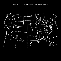
- Example "mpex02" shows Africa on a stereographic projection, with an
elliptical perimeter.
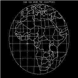
- Example "mpex03" shows simplified continental outlines on a Mercator
projection.It uses a version of MAPEOD which scrubs all but the principal
land masses. The left and right area identifiers are used to determine
which segments to keep and which to scrub. Segment-number information,
obtained by running the program shown in example 9, could have been
used instead.
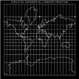
- Example "mpex04" shows the world in three parts, using stereographic
projections for the poles and a Mercator projection for the equatorial
belt.
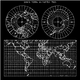
- Example "mpex05" shows maximal-area plots for all types of EZMAP
projections.
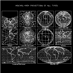
- Example "mpex06" shows the effect of the rotation angle ROTA on a
satellite-view projection.
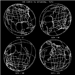
- Example "mpex07" presents a scheme for labelling the meridians on
certain types of maps. It is difficult to write an algorithm for doing
this in general.
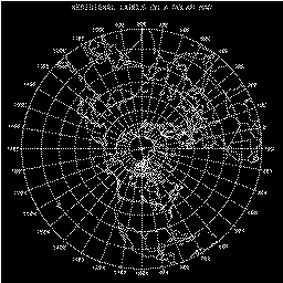
- Example "mpex08" demonstrates how the routine MAPUSR is used.
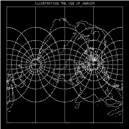
- Example "mpex09" shows the numbering of segments in the outline
dataset 'CO' and presents a program which may be used to obtain such
plots for the other outline datasets. This example is somewhat out of
date, since the segment numbers are only of use in a user version of the
routine named MAPEOD and it is probably better now to use the left and
right area identifiers, rather than the segment numbers, in deciding
which outline segments to keep and which to omit.The technique used to
break the maps into rectangular pieces and present each piece individually
may be useful in its own right.
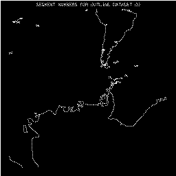 (frame 1)
- Example "mpex10" shows how to use the routine MAPTRI and the
cell-array capability of GKS to obtain what is essentially a contour
map of a data field defined on the surface of the globe.
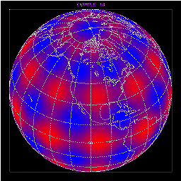
- Example "mpex11" shows three different portions of the earth as
represented by the database "Earth..1", which was added to EZMAP
in April, 1998. On each frame, there are three concentric circles.
Within the innermost circle, the dataset is shown at level 4 (which
includes states); within the surrounding ring, the dataset is shown
at level 3 (which includes countries, but not states); within the ring
around that, the dataset is shown at level 2 (including continents
and pseudo-continents, but no countries or states); outside the largest
ring, the dataset is shown at level 1 (including land-water boundaries,
but nothing else.)
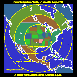 (frame 1)
- Example "mpex12" does not draw a plot. It only produces print output.
It illustrates how to use EZMAPB routines that retrieve information
about the areas defined by a database.
- Example "mpexfi" (the "final" example for EZMAP itself) shows
how to draw lines, defined by points for which one has the latitudes
and longitudes, on a map produced by EZMAP.

- Example "tezmap" produces a number of frames; it is intended to
demonstrate minimal functioning of EZMAP.
 (frame 1)
- Example "tezmpa" shows a solid-colored map of a portion of Northern
Europe, with lines of latitude and longitude over ocean only. The
outline data used are from the outline dataset 'PO'. Compare the
plot with that produced by "tezmpb".
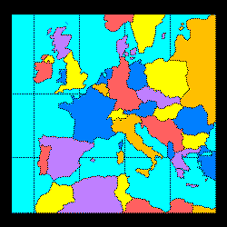
- Example "tezmpb" shows a solid-colored map of a portion of Northern
Europe, with lines of latitude and longitude over ocean only. The
outline data used are from the map database "Earth..1". Compare the
plot with that produced by "tezmpa".
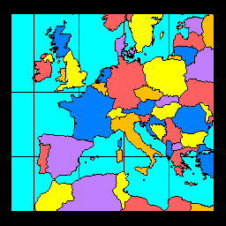
- Example "eezmpa" shows a solid-colored map of the world on a Mercator
projection, with lines of latitude and longitude over ocean only.
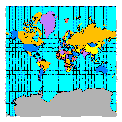
Many of the above example programs use a subroutine named BNDARY to draw a
boundary line indicating where the edge of the plotter frame is. This
subroutine is not a part of EZMAP or of the NCAR plot package. When you
run one of these, the code for the subroutine BNDARY will be put in a file
named "mpexcc.f".
The following CONPACK example illustrates the use of the satellite-view
projection and various routines from the package EZMAPA:
- Example "cpex10" shows a view of the western United States as seen from
a satellite above Washington, D.C. Within seven degrees of Boulder, Colorado,
color-filled contour bands are shown. The EZMAPA routine MAPBLM is used with
an appropriate area map, allowing state boundaries to be in black over the
contoured area and in white elsewhere. The EZMAP routine MAPGRM is used with
an appropriate area map, allowing 1-degree grid lines to be drawn outside
the contoured area, but not inside it. Mapping capabilities of PLOTCHAR are
used to create state labels that appear to be written on the surface of the
globe and projected along with it.
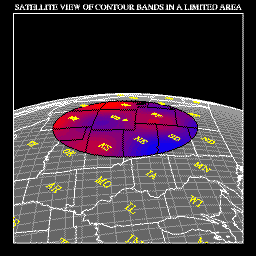
Prior to 1998, there were four EZMAP outline datasets, indexed as follows:
| Index | Name | Contents |
| 1 | 'CO' | Continental outlines only. |
| 2 | 'US' | U.S. state outlines only. |
| 3 | 'PS' | Continental, U.S. state, and international outlines. |
| 4 | 'PO' | Continental and international outlines. |
These datasets were accessed by calling one or more of the routines MAPBLA,
MAPBLM, and MAPLOT. Associated with each outline segment in the old datasets
were two integers identifying, respectively, the areas to the left and right
of the outline segment. These "area identifiers" could be used, in a user
version of the subroutine MAPEOD, to cull unwanted segments from a map; they
also allowed the user to produce solid-color maps. This
table shows the association between the old
area identifiers and the names of the areas they identified.
In 1998, a new map database was created, called "Earth..1". It has a
different structure and is accessed using the EZMAPB routines MPLNAM,
MPLNDM, MPLNDR, MPLNRI. The areas defined by the new database also have
numeric area identifiers, but specific numeric values should not be embedded
in user programs; instead, area names should be used. The names of the
areas defined by the new database are shown in this
table.
About 1963, R. L. Parker of UCSD wrote the original code, named SUPERMAP,
using outline data generated by Hershey. This was adapted for use at NCAR
by Lee, in 1968. Revisions occurred in January, 1969, and in May, 1971.
The code was put in standard NSSL form in October, 1973. Further revisions
occurred in July, 1974, in August, 1976, and in July, 1978. In late 1984
and early 1985, the code was heavily revised to achieve compatibility with
FORTRAN-77 and GKS, to remove errors, to augment the outline datasets, and
to add enough controls to make user modification of the code unnecessary.
In 1987, certain changes were made as part of preparing to introduce the
solid-color routine named MAPBLA: A routine named MAPEOS was removed and
a routine named MAPEOD was implemented in its place; intensity parameters
'I1', 'I2', etc., were removed and the color-index parameters 'C1', 'C2',
etc. were implemented instead. Later in 1987, the routines of EZMAPA were
made available. In 1992, an inverse-transformation routine was added to
the package. In 1998, the routines of EZMAPB and the new database
"Earth..1" were added.
Cicely Ridley, Jay Chalmers, and Dave Kennison (the current curator) have
all had a hand in the creation of EZMAP.
Data points in the continental-outline portions of the 'CO', 'PO', and
'PS' outline datasets are about one degree apart and the coordinates are
accurate to .01 degree. Data points in the U.S. state outlines in the
'PS' and 'US' outline datasets and in the new database "Earth..1" are
about .05 degrees apart and the coordinates are accurate to .001 degree.
Both the spacing and the accuracy of the international boundaries in all
the old and new datasets falls somewhere between these two extremes.
Hershey, A.V., "The Plotting of Maps on a CRT Printer." NWL Report no. 1844,
1963.
Lee, Tso-Hwa, "Students' Summary Reports, Work-Study Program in Scientific
Computing". NCAR, 1968.
Parker, R.L., "2UCSD SUPERMAP: World Plotting Package".
Steers, J.A., "An Introduction to the Study of Map Projections". University
of London Press, 1962.
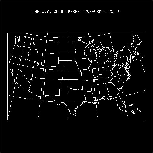
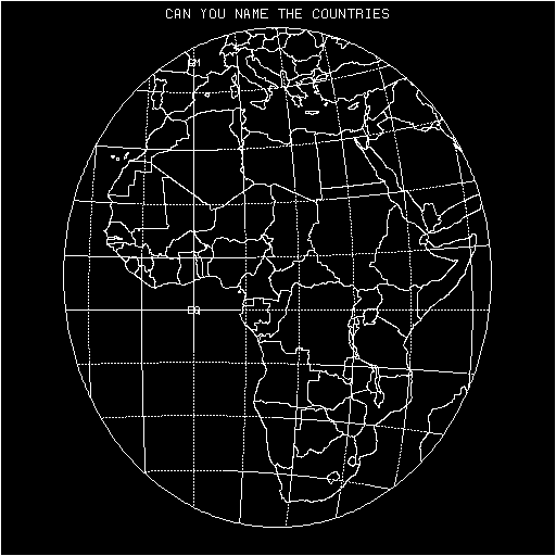
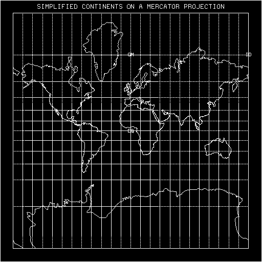

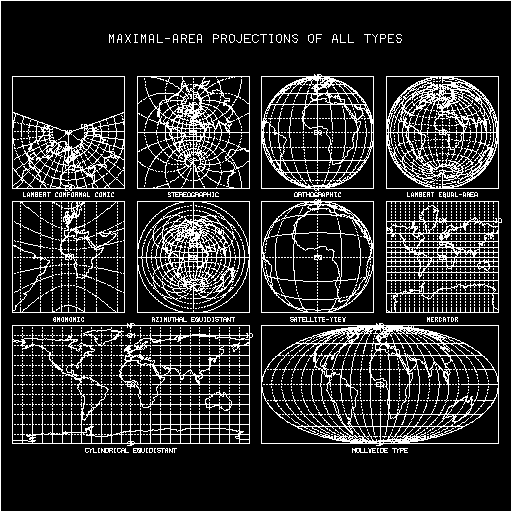

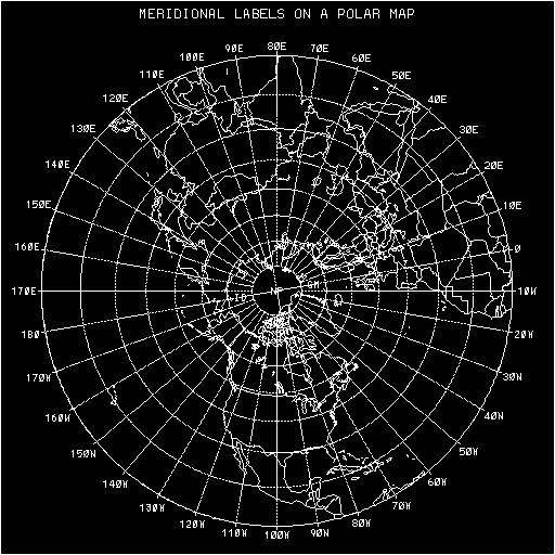
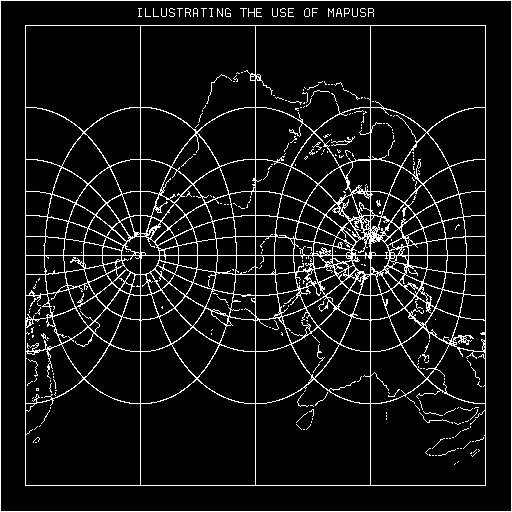
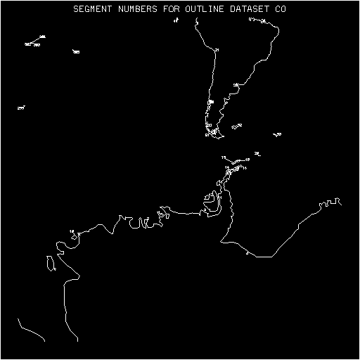 (frame 1)
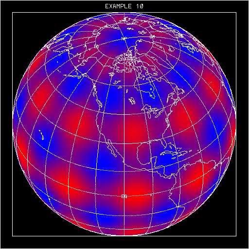
 (frame 1)
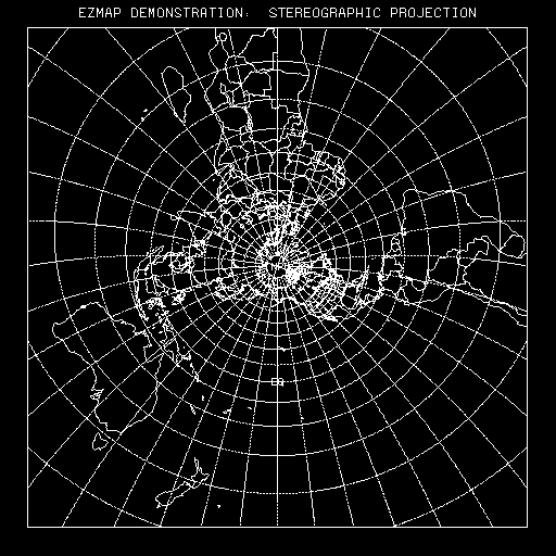 (frame 1)